|
|
|
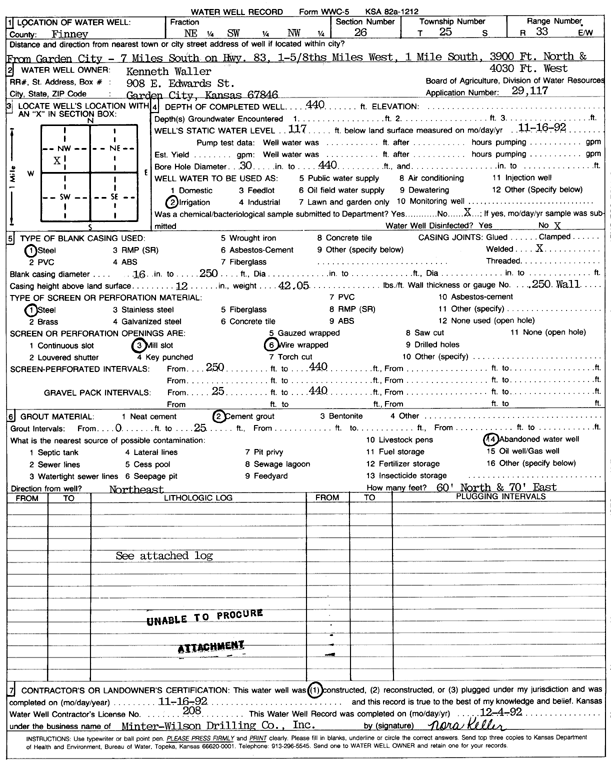
Specific Water Well Detail |
|
|
| Location Info | |||
| Owner: Waller, Kenneth | Status: Constructed | ||
| Location: T25S, R33W, Sec. 26, NE SW NW | County: Finney | ||
| Directions: from Garden City: 7 mi S on Hwy 83, 1.6 mi W, 1 mi S, 3900 feet N, and 4030 feet W | |||
| Latitude: 37.8541768 | Longitude: -100.9163797 | Datum NAD 27 | |
| Latitude: 37.8542005 | Longitude: -100.9168222 | Datum NAD 83 | |
| Longitude and latitude calculated by Survey from township-range-section-quarter calls. Only good to within the quarter call accuracy. | |||
| View well on interactive map | |||
| General Info | ||
| Well Depth: 440 ft. | Elevation: ft. | |
| Static Water Level: 117 ft. | Est. Yield: gpm. | |
| Comp. Date: 16-Nov-1992 | Well Use: Irrigation | |
| DWR Applic. #: 29117 | Other ID: | |
| Links | |
| No Wizard information available. | |
| View info from WIMAS Water Right Data base... | |
| Driller Info | ||
| Driller: Minter-Wilson Drlg. Co., Inc. | License #: 208 | |
| Scanned Form | View scan |
|
Chemical Sample Submitted?: No
Water Well disinfected?: | ||
| Ground water encountered: 0 ft. , 0 ft. , 0 ft. | ||
| Pump test data: Well water was 0 ft after 0 hours pumping 0 gpm | ||
| Casing Info | ||
| Casing Type: Steel
Casing Joints: |
Diam: 16 in. to 250 ft
Diam: 0 in. to 0 ft Diam: 0 in. to 0 ft | |
| Casing height above land surface: in
Casing Weight: lbs/ft Wall thickness or gauge no.: | ||
| Screen and Perforation Info | ||
| Screen Type: Steel | Screen Openings: Wire wrapped | |
| Screen-perforated intervals | From: 250 ft to 440 ft
From: 0 ft to 0 ft From: 0 ft to 0 ft | |
| Gravel pack intervals | From: ft to ft | |
| Grout Info | ||
| Grout used: Cement grout | From: 0 to 25 ft
From: 0 to 0 ft From: 0 to 0 ft | |
| Source of Possible Contamination | ||
| Source: Abandoned water well | ||
| Direction from well: | Distance: 0 ft | |
| Lithologic Log
(log data not edited or checked by the KGS.) | ||
| From: 0 ft. to 1 ft. | Type: CLAY | |
| From: 1 ft. to 22 ft. | Type: FINE SAND | |
| From: 22 ft. to 53 ft. | Type: SANDY CLAY | |
| From: 53 ft. to 60 ft. | Type: SAND & GRAVEL | |
| From: 60 ft. to 140 ft. | Type: FINE GRAVEL | |
| From: 140 ft. to 145 ft. | Type: CLAY | |
| From: 145 ft. to 170 ft. | Type: FINE GRAVEL | |
| From: 170 ft. to 196 ft. | Type: MEDIUM GRAVEL | |
| From: 196 ft. to 251 ft. | Type: CLAY | |
| From: 251 ft. to 260 ft. | Type: SAND & GRAVEL | |
| From: 260 ft. to 267 ft. | Type: CLAY | |
| From: 267 ft. to 283 ft. | Type: SANDY CLAY | |
| From: 283 ft. to 293 ft. | Type: SAND & GRAVEL | |
| From: 293 ft. to 300 ft. | Type: CLAY & GRAVEL | |
| From: 300 ft. to 307 ft. | Type: SANDY CLAY | |
| From: 307 ft. to 312 ft. | Type: SAND & GRAVEL | |
| From: 312 ft. to 318 ft. | Type: ROCK & CLAY | |
| From: 318 ft. to 341 ft. | Type: CLAY & GRAVEL | |
| From: 341 ft. to 359 ft. | Type: SAND & GRAVEL | |
| From: 359 ft. to 373 ft. | Type: SANDY CLAY | |
| From: 373 ft. to 380 ft. | Type: SAND & GRAVEL | |
| From: 380 ft. to 392 ft. | Type: SANDY CLAY | |
| From: 392 ft. to 411 ft. | Type: CLAY & GRAVEL | |
| From: 411 ft. to 430 ft. | Type: SAND & GRAVEL | |
| From: 430 ft. to 457 ft. | Type: SANDY CLAY | |
| From: 457 ft. to 464 ft. | Type: CLAY | |