|
|
|
Specific Water Well Detail |
|
|
| Location Info | |||
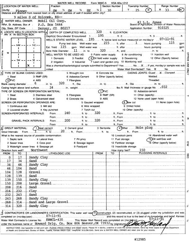
| Owner: Mobil Oil Corp. | Status: Constructed | ||
| Location: T25S, R33W, Sec. 30, SW SW SE | County: Finney | ||
| Directions: 9 mi S of Holcomb | |||
| Latitude: 37.8448932 | Longitude: -100.9825757 | Datum NAD 27 | |
| Latitude: 37.8449171 | Longitude: -100.9830209 | Datum NAD 83 | |
| Longitude and latitude calculated by Survey from township-range-section-quarter calls. Only good to within the quarter call accuracy. | |||
| View well on interactive map | |||
| General Info | ||
| Well Depth: 320 ft. | Elevation: ft. | |
| Static Water Level: 195 ft. | Est. Yield: 115 gpm. | |
| Comp. Date: 11-Jul-1991 | Well Use: Oil Field Water Supply | |
| DWR Applic. #: 910325 | Other ID: L.L. Jones 2 | |
| Links | |
| No Wizard information available. | |
| View info from WIMAS Water Right Data base... | |
| Driller Info | ||
| Driller: Howard Drilling Company AG, LLC | License #: 430 | |
| Scanned Form | View scan |
|
Chemical Sample Submitted?: No
Water Well disinfected?: | ||
| Ground water encountered: 195 ft. , 0 ft. , 0 ft. | ||
| Pump test data: Well water was 215 ft after 1 hours pumping 115 gpm | ||
| Casing Info | ||
| Casing Type: PVC
Casing Joints: |
Diam: 6 in. to 320 ft
Diam: 0 in. to 0 ft Diam: 0 in. to 0 ft | |
| Casing height above land surface: in
Casing Weight: lbs/ft Wall thickness or gauge no.: | ||
| Screen and Perforation Info | ||
| Screen Type: PVC | Screen Openings: Saw cut | |
| Screen-perforated intervals | From: 240 ft to 320 ft
From: 0 ft to 0 ft From: 0 ft to 0 ft | |
| Gravel pack intervals | From: ft to ft | |
| Grout Info | ||
| Grout used: Neat cement, | From: 1 to 20 ft
From: 0 to 0 ft From: 0 to 0 ft | |
| Source of Possible Contamination | ||
| Source: Oil well/gas well | ||
| Direction from well: | Distance: 0 ft | |
| Lithologic Log
(Log data entered by KGS.) | ||
| From: 0 ft. to 17 ft. | sandy clay | |
| From: 17 ft. to 34 ft. | sand | |
| From: 34 ft. to 46 ft. | sandy clay | |
| From: 46 ft. to 104 ft. | sand | |
| From: 104 ft. to 128 ft. | gravel | |
| From: 128 ft. to 139 ft. | sand | |
| From: 139 ft. to 150 ft. | sandy clay | |
| From: 150 ft. to 208 ft. | large gravel | |
| From: 208 ft. to 216 ft. | sand | |
| From: 216 ft. to 232 ft. | clay | |
| From: 232 ft. to 243 ft. | sand | |
| From: 243 ft. to 268 ft. | sandy clay | |
| From: 268 ft. to 314 ft. | sand and large gravel | |
| From: 314 ft. to 320 ft. | sandy clay | |