|
|
|
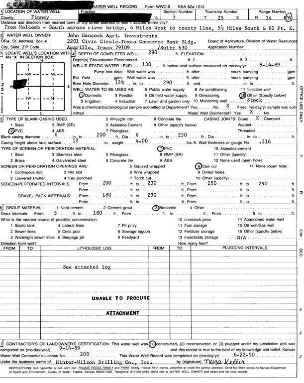
Specific Water Well Detail |
|
|
| Location Info | |||
| Owner: John Hancock Agri. Investments | Status: Constructed | ||
| Location: T25S, R34W, Sec. 7, SW SW NW | County: Finney | ||
| Directions: S across Holcomb river bridge, 6 mi W to county line, 5.5 mi S, 60' E | |||
| Latitude: 37.8951777 | Longitude: -101.102002 | Datum NAD 27 | |
| Latitude: 37.8951998 | Longitude: -101.1024486 | Datum NAD 83 | |
| Longitude and latitude calculated by Survey from township-range-section-quarter calls. Only good to within the quarter call accuracy. | |||
| View well on interactive map | |||
| General Info | ||
| Well Depth: 290 ft. | Elevation: ft. | |
| Static Water Level: 130 ft. | Est. Yield: gpm. | |
| Comp. Date: 14-Sep-1989 | Well Use: Domestic, Livestock | |
| DWR Applic. #: | Other ID: | |
| Driller Info | ||
| Driller: Minter-Wilson Drlg. Co., Inc. | License #: 208 | |
| Scanned Form | View scan |
|
Chemical Sample Submitted?: No
Water Well disinfected?: | ||
| Ground water encountered: 0 ft. , 0 ft. , 0 ft. | ||
| Pump test data: Well water was 0 ft after 0 hours pumping 0 gpm | ||
| Casing Info | ||
| Casing Type: PVC
Casing Joints: |
Diam: 6 in. to 200 ft
Diam: 0 in. to 0 ft Diam: 0 in. to 0 ft | |
| Casing height above land surface: in
Casing Weight: lbs/ft Wall thickness or gauge no.: | ||
| Screen and Perforation Info | ||
| Screen Type: PVC | Screen Openings: Saw cut | |
| Screen-perforated intervals | From: 200 ft to 230 ft
From: 250 ft to 290 ft From: 0 ft to 0 ft | |
| Gravel pack intervals | From: ft to ft | |
| Grout Info | ||
| Grout used: Bentonite | From: 5 to 180 ft
From: 0 to 0 ft From: 0 to 0 ft | |
| Source of Possible Contamination | ||
| Source: OTHER | ||
| Direction from well: | Distance: 0 ft | |
| Lithologic Log
(log data not edited or checked by the KGS.) | ||
| From: 0 ft. to 1 ft. | Type: CLAY | |
| From: 1 ft. to 30 ft. | Type: FINE SAND | |
| From: 30 ft. to 36 ft. | Type: CLAY | |
| From: 36 ft. to 40 ft. | Type: SAND & GRAVEL | |
| From: 40 ft. to 63 ft. | Type: COARSE GRAVEL | |
| From: 63 ft. to 98 ft. | Type: SANDY CLAY | |
| From: 98 ft. to 127 ft. | Type: SAND & GRAVEL | |
| From: 127 ft. to 155 ft. | Type: SANDY CLAY | |
| From: 155 ft. to 169 ft. | Type: SAND & GRAVEL | |
| From: 169 ft. to 194 ft. | Type: SANDY CLAY | |
| From: 194 ft. to 203 ft. | Type: SAND & GRAVEL | |
| From: 203 ft. to 233 ft. | Type: COARSE GRAVEL | |
| From: 233 ft. to 252 ft. | Type: SANDY CLAY | |
| From: 252 ft. to 261 ft. | Type: SAND & GRAVEL | |
| From: 261 ft. to 268 ft. | Type: SANDY CLAY | |
| From: 268 ft. to 288 ft. | Type: SAND & GRAVEL | |
| From: 288 ft. to 291 ft. | Type: SANDY CLAY | |
| From: 291 ft. to 320 ft. | Type: SANDSTONE | |