|
|
|
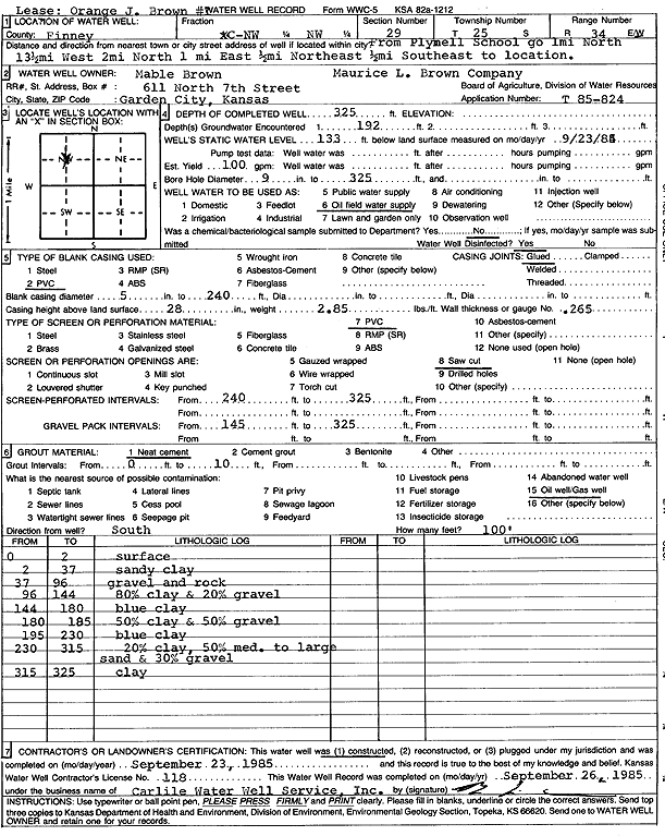
Specific Water Well Detail |
|
|
| Location Info | |||
| Owner: Mobill Oil Corp./Mable Brown | Status: Constructed | ||
| Location: T25S, R34W, Sec. 29, C NW NW | County: Finney | ||
| Directions: from Plymell school: 1 mi N, 13.5 mi W, 2 mi N, 1 mi E, 0.5 mi NE, and 0.5 mi SE | |||
| Latitude: 37.8557373 | Longitude: -101.0830763 | Datum NAD 27 | |
| Latitude: 37.8557597 | Longitude: -101.0835231 | Datum NAD 83 | |
| Longitude and latitude calculated by Survey from township-range-section-quarter calls. Only good to within the quarter call accuracy. | |||
| View well on interactive map | |||
| General Info | ||
| Well Depth: 325 ft. | Elevation: ft. | |
| Static Water Level: 133 ft. | Est. Yield: 100 gpm. | |
| Comp. Date: 23-Sep-1985 | Well Use: Oil Field Water Supply | |
| DWR Applic. #: T85-824 | Other ID: O.J. Brown 1 | |
| Driller Info | ||
| Driller: Bernard E. Carlile Water Well Service, Inc. | License #: 118 | |
| Scanned Form | View scan |
|
Chemical Sample Submitted?: No
Water Well disinfected?: | ||
| Ground water encountered: 192 ft. , 0 ft. , 0 ft. | ||
| Pump test data: Well water was 192 ft after 0 hours pumping 0 gpm | ||
| Casing Info | ||
| Casing Type: PVC
Casing Joints: |
Diam: 5 in. to 240 ft
Diam: 0 in. to 0 ft Diam: 0 in. to 0 ft | |
| Casing height above land surface: in
Casing Weight: lbs/ft Wall thickness or gauge no.: | ||
| Screen and Perforation Info | ||
| Screen Type: PVC | Screen Openings: Saw cut | |
| Screen-perforated intervals | From: 240 ft to 325 ft
From: 0 ft to 0 ft From: 0 ft to 0 ft | |
| Gravel pack intervals | From: ft to ft | |
| Grout Info | ||
| Grout used: Neat cement | From: 0 to 10 ft
From: 0 to 0 ft From: 0 to 0 ft | |
| Source of Possible Contamination | ||
| Source: Oil well/gas well | ||
| Direction from well: | Distance: 0 ft | |
| Lithologic Log
(Log data entered by KGS.) | ||
| From: 0 ft. to 2 ft. | surface | |
| From: 2 ft. to 37 ft. | sandy clay | |
| From: 37 ft. to 96 ft. | gravel and rock | |
| From: 96 ft. to 144 ft. | 80% clay and 20% gravel | |
| From: 144 ft. to 180 ft. | blue clay | |
| From: 180 ft. to 185 ft. | 50% clay and 50% gravel | |
| From: 185 ft. to 230 ft. | blue clay | |
| From: 230 ft. to 315 ft. | 20% clay, 50% medium to large sand and 30% gravel | |
| From: 315 ft. to 325 ft. | clay | |