|
|
|
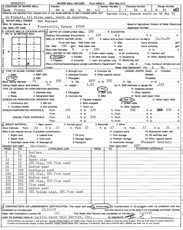
Specific Water Well Detail |
|
|
| Location Info | |||
| Owner: Husband, Bob | Status: Constructed | ||
| Location: T26S, R31W, Sec. 1, SW SW SE | County: Finney | ||
| Directions: from Garden City: S on Hwy 83 to Plymell, 11.5 mi E, N to site | |||
| Latitude: 37.8108462 | Longitude: -100.6591976 | Datum NAD 27 | |
| Latitude: 37.8108691 | Longitude: -100.6596309 | Datum NAD 83 | |
| Longitude and latitude calculated by Survey from township-range-section-quarter calls. Only good to within the quarter call accuracy. | |||
| View well on interactive map | |||
| General Info | ||
| Well Depth: 280 ft. | Elevation: ft. | |
| Static Water Level: 105 ft. | Est. Yield: 100 gpm. | |
| Comp. Date: 26-Dec-1989 | Well Use: Domestic | |
| DWR Applic. #: | Other ID: | |
| Driller Info | ||
| Driller: Bernard E. Carlile Water Well Service, Inc. | License #: 118 | |
| Scanned Form | View scan |
|
Chemical Sample Submitted?: No
Water Well disinfected?: | ||
| Ground water encountered: 105 ft. , 0 ft. , 0 ft. | ||
| Pump test data: Well water was 0 ft after 0 hours pumping 0 gpm | ||
| Casing Info | ||
| Casing Type: PVC
Casing Joints: |
Diam: 5 in. to 100 ft
Diam: 0 in. to 0 ft Diam: 0 in. to 0 ft | |
| Casing height above land surface: in
Casing Weight: lbs/ft Wall thickness or gauge no.: | ||
| Screen and Perforation Info | ||
| Screen Type: PVC | Screen Openings: Saw cut | |
| Screen-perforated intervals | From: 100 ft to 180 ft
From: 200 ft to 280 ft From: 0 ft to 0 ft | |
| Gravel pack intervals | From: ft to ft | |
| Grout Info | ||
| Grout used: Bentonite | From: 10 to 15 ft
From: 15 to 17 ft From: 17 to 31 ft | |
| Source of Possible Contamination | ||
| Source: OTHER | ||
| Direction from well: | Distance: 0 ft | |
| Lithologic Log
(Log data entered by KGS.) | ||
| From: 0 ft. to 2 ft. | surface | |
| From: 2 ft. to 13 ft. | clay | |
| From: 13 ft. to 40 ft. | sandy clay | |
| From: 40 ft. to 51 ft. | 60% clay, 40% fine sand | |
| From: 51 ft. to 80 ft. | medium sand | |
| From: 80 ft. to 120 ft. | med/large sand | |
| From: 120 ft. to 133 ft. | 65% clay, 35% fine sand | |
| From: 133 ft. to 180 ft. | medium sand | |
| From: 180 ft. to 205 ft. | 80% clay, 20% fine sand | |
| From: 205 ft. to 220 ft. | fine sand | |
| From: 220 ft. to 265 ft. | medium sand | |
| From: 265 ft. to 280 ft. | 70% yellow clay, 30% fine sand | |