|
|
|
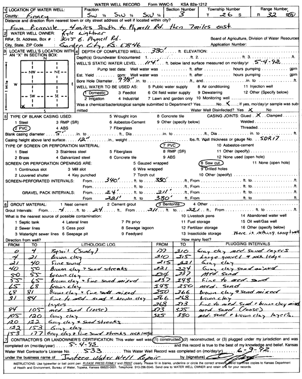
Specific Water Well Detail |
|
|
| Location Info | |||
| Owner: Lightner, Kyle | Status: Constructed | ||
| Location: T26S, R32W, Sec. 3, SW SW SW | County: Finney | ||
| Directions: from Pierceville: 4 mi S to Plymell Rd and 7 mi E | |||
| Latitude: 37.8108419 | Longitude: -100.8145903 | Datum NAD 27 | |
| Latitude: 37.8108655 | Longitude: -100.8150293 | Datum NAD 83 | |
| Longitude and latitude calculated by Survey from township-range-section-quarter calls. Only good to within the quarter call accuracy. | |||
| View well on interactive map | |||
| General Info | ||
| Well Depth: 380 ft. | Elevation: ft. | |
| Static Water Level: 114 ft. | Est. Yield: gpm. | |
| Comp. Date: 04-May-1992 | Well Use: Domestic | |
| DWR Applic. #: | Other ID: | |
| Driller Info | ||
| Driller: Jantzen Water Well | License #: 533 | |
| Scanned Form | View scan |
|
Chemical Sample Submitted?: No
Water Well disinfected?: | ||
| Ground water encountered: 114 ft. , 0 ft. , 0 ft. | ||
| Pump test data: Well water was 0 ft after 0 hours pumping 0 gpm | ||
| Casing Info | ||
| Casing Type: PVC
Casing Joints: |
Diam: 5 in. to 0 ft
Diam: 0 in. to 0 ft Diam: 0 in. to 0 ft | |
| Casing height above land surface: in
Casing Weight: lbs/ft Wall thickness or gauge no.: | ||
| Screen and Perforation Info | ||
| Screen Type: PVC | Screen Openings: Saw cut | |
| Screen-perforated intervals | From: 340 ft to 380 ft
From: 0 ft to 0 ft From: 0 ft to 0 ft | |
| Gravel pack intervals | From: ft to ft | |
| Grout Info | ||
| Grout used: Bentonite | From: 4 to 24 ft
From: 211 to 221 ft From: 0 to 0 ft | |
| Source of Possible Contamination | ||
| Source: OTHER | ||
| Direction from well: | Distance: 0 ft | |
| Lithologic Log
(Log data entered by KGS.) | ||
| From: 0 ft. to 4 ft. | topsoil (sandy) | |
| From: 4 ft. to 21 ft. | brown clay | |
| From: 21 ft. to 40 ft. | fine sand | |
| From: 40 ft. to 50 ft. | brown clay and sand streaks | |
| From: 50 ft. to 55 ft. | brown clay | |
| From: 55 ft. to 65 ft. | brown clay and fine sand mixed | |
| From: 65 ft. to 68 ft. | brown clay | |
| From: 68 ft. to 81 ft. | brown clay and fine sand mixed | |
| From: 81 ft. to 84 ft. | fine to medium sand and brown clay layers | |
| From: 84 ft. to 105 ft. | medium sand (loose) | |
| From: 105 ft. to 120 ft. | gray clay | |
| From: 120 ft. to 122 ft. | gray clay and sand streaks | |
| From: 122 ft. to 153 ft. | gray clay | |
| From: 153 ft. to 177 ft. | gray clay and fine sand streaks rock ledges | |
| From: 177 ft. to 210 ft. | gray clay medium sand layers | |
| From: 210 ft. to 215 ft. | large gravel and rock ledge | |
| From: 215 ft. to 221 ft. | gray clay | |
| From: 221 ft. to 224 ft. | gray clay sand mixed | |
| From: 224 ft. to 237 ft. | medium sand | |
| From: 237 ft. to 248 ft. | fine to medium sand | |
| From: 248 ft. to 250 ft. | medium sand | |
| From: 250 ft. to 266 ft. | brown clay and sand mixed | |
| From: 266 ft. to 268 ft. | brown clay | |
| From: 268 ft. to 273 ft. | fine to medium sand and brown clay mixed | |
| From: 273 ft. to 325 ft. | medium sand (loose) | |
| From: 325 ft. to 380 ft. | medium sand and brown clay layers | |