|
|
|
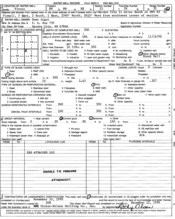
Specific Water Well Detail |
|
|
| Location Info | |||
| Owner: Gigot, Dean | Status: Constructed | ||
| Location: T26S, R32W, Sec. 15, NW NW SE | County: Finney | ||
| Directions: from Plymell: 3 mi E, 2 mi S, 1 mi E, 2340 feet N, 2610 feet W from SE corner of section | |||
| Latitude: 37.7869134 | Longitude: -100.8055311 | Datum NAD 27 | |
| Latitude: 37.7869371 | Longitude: -100.80597 | Datum NAD 83 | |
| Longitude and latitude calculated by Survey from township-range-section-quarter calls. Only good to within the quarter call accuracy. | |||
| View well on interactive map | |||
| General Info | ||
| Well Depth: 300 ft. | Elevation: ft. | |
| Static Water Level: 184 ft. | Est. Yield: gpm. | |
| Comp. Date: 23-Nov-1990 | Well Use: Domestic, Livestock | |
| DWR Applic. #: | Other ID: | |
| Driller Info | ||
| Driller: Minter-Wilson Drlg. Co., Inc. | License #: 208 | |
| Scanned Form | View scan |
|
Chemical Sample Submitted?: No
Water Well disinfected?: | ||
| Ground water encountered: 0 ft. , 0 ft. , 0 ft. | ||
| Pump test data: Well water was 0 ft after 0 hours pumping 0 gpm | ||
| Casing Info | ||
| Casing Type: PVC
Casing Joints: |
Diam: 5 in. to 260 ft
Diam: 0 in. to 0 ft Diam: 0 in. to 0 ft | |
| Casing height above land surface: in
Casing Weight: lbs/ft Wall thickness or gauge no.: | ||
| Screen and Perforation Info | ||
| Screen Type: PVC | Screen Openings: Saw cut | |
| Screen-perforated intervals | From: 260 ft to 300 ft
From: 0 ft to 0 ft From: 0 ft to 0 ft | |
| Gravel pack intervals | From: ft to ft | |
| Grout Info | ||
| Grout used: Cement grout, Bentonite | From: 0 to 20 ft
From: 20 to 160 ft From: 0 to 0 ft | |
| Source of Possible Contamination | ||
| Source: OTHER | ||
| Direction from well: | Distance: 0 ft | |
| Lithologic Log
(log data not edited or checked by the KGS.) | ||
| From: 0 ft. to 3 ft. | Type: CLAY | |
| From: 3 ft. to 41 ft. | Type: SANDY CLAY | |
| From: 41 ft. to 73 ft. | Type: FINE SAND | |
| From: 73 ft. to 161 ft. | Type: SAND & GRAVEL | |
| From: 161 ft. to 177 ft. | Type: CLAY | |
| From: 177 ft. to 184 ft. | Type: SAND & GRAVEL | |
| From: 184 ft. to 222 ft. | Type: CLAY | |
| From: 222 ft. to 237 ft. | Type: SAND & GRAVEL | |
| From: 237 ft. to 272 ft. | Type: CLAY | |
| From: 272 ft. to 301 ft. | Type: SAND & GRAVEL | |
| From: 301 ft. to 310 ft. | Type: CLAY | |