|
|
|
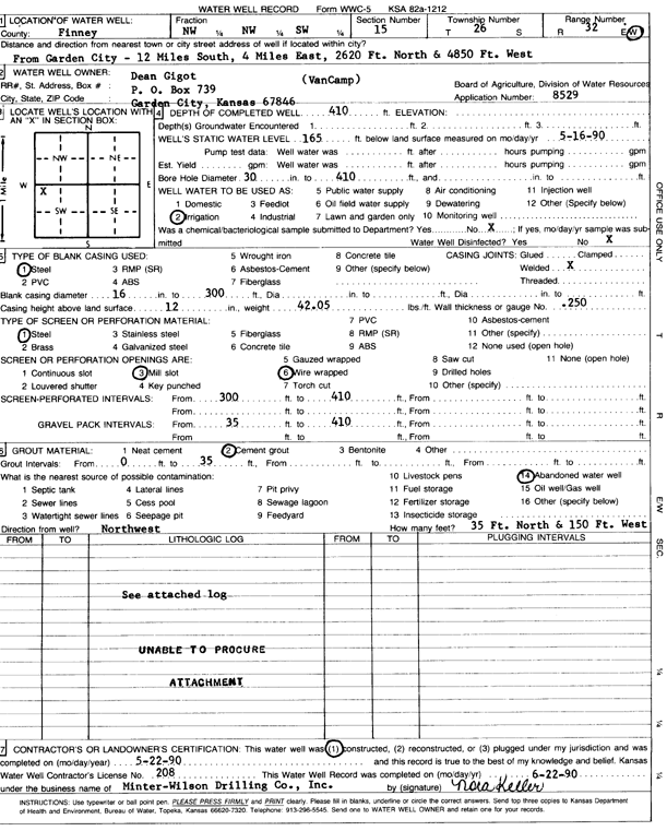
Specific Water Well Detail |
|
|
| Location Info | |||
| Owner: Gigot, Dean | Status: Constructed | ||
| Location: T26S, R32W, Sec. 15, NW NW SW | County: Finney | ||
| Directions: from Garden City: 12 mi S, 4 mi W, 2620 feet N, and 4850 feet W | |||
| Latitude: 37.7869435 | Longitude: -100.8146184 | Datum NAD 27 | |
| Latitude: 37.7869672 | Longitude: -100.8150577 | Datum NAD 83 | |
| Longitude and latitude calculated by Survey from township-range-section-quarter calls. Only good to within the quarter call accuracy. | |||
| View well on interactive map | |||
| General Info | ||
| Well Depth: 410 ft. | Elevation: ft. | |
| Static Water Level: 165 ft. | Est. Yield: gpm. | |
| Comp. Date: 22-May-1990 | Well Use: Irrigation | |
| DWR Applic. #: 8529 | Other ID: | |
| Links | |
| No Wizard information available. | |
| View info from WIMAS Water Right Data base... | |
| Driller Info | ||
| Driller: Minter-Wilson Drlg. Co., Inc. | License #: 208 | |
| Scanned Form | View scan |
|
Chemical Sample Submitted?: No
Water Well disinfected?: | ||
| Ground water encountered: 0 ft. , 0 ft. , 0 ft. | ||
| Pump test data: Well water was 0 ft after 0 hours pumping 0 gpm | ||
| Casing Info | ||
| Casing Type: Steel
Casing Joints: |
Diam: 16 in. to 300 ft
Diam: 0 in. to 0 ft Diam: 0 in. to 0 ft | |
| Casing height above land surface: in
Casing Weight: lbs/ft Wall thickness or gauge no.: | ||
| Screen and Perforation Info | ||
| Screen Type: Steel | Screen Openings: Mill slot | |
| Screen-perforated intervals | From: 300 ft to 410 ft
From: 0 ft to 0 ft From: 0 ft to 0 ft | |
| Gravel pack intervals | From: ft to ft | |
| Grout Info | ||
| Grout used: Cement grout | From: 0 to 35 ft
From: 0 to 0 ft From: 0 to 0 ft | |
| Source of Possible Contamination | ||
| Source: Abandoned water well | ||
| Direction from well: | Distance: 0 ft | |
| Lithologic Log
(log data not edited or checked by the KGS.) | ||
| From: 0 ft. to 1 ft. | Type: CLAY | |
| From: 1 ft. to 33 ft. | Type: FINE SAND | |
| From: 33 ft. to 53 ft. | Type: SANDY CLAY | |
| From: 53 ft. to 62 ft. | Type: FINE SAND | |
| From: 62 ft. to 75 ft. | Type: SANDY CLAY | |
| From: 75 ft. to 136 ft. | Type: GRAVEL | |
| From: 136 ft. to 148 ft. | Type: SANDY CLAY | |
| From: 148 ft. to 169 ft. | Type: SAND & GRAVEL | |
| From: 169 ft. to 170 ft. | Type: CLAY | |
| From: 170 ft. to 173 ft. | Type: SANDSTONE | |
| From: 173 ft. to 184 ft. | Type: CLAY | |
| From: 184 ft. to 195 ft. | Type: SAND & GRAVEL | |
| From: 195 ft. to 201 ft. | Type: SANDY CLAY | |
| From: 201 ft. to 293 ft. | Type: CLAY | |
| From: 293 ft. to 304 ft. | Type: SANDSTONE | |
| From: 304 ft. to 312 ft. | Type: SAND | |
| From: 312 ft. to 407 ft. | Type: SAND & GRAVEL | |
| From: 407 ft. to 428 ft. | Type: SANDY CLAY | |
| From: 428 ft. to 436 ft. | Type: SAND & GRAVEL | |
| From: 436 ft. to 447 ft. | Type: CLAY | |
| From: 447 ft. to 455 ft. | Type: SHALE | |