|
|
|
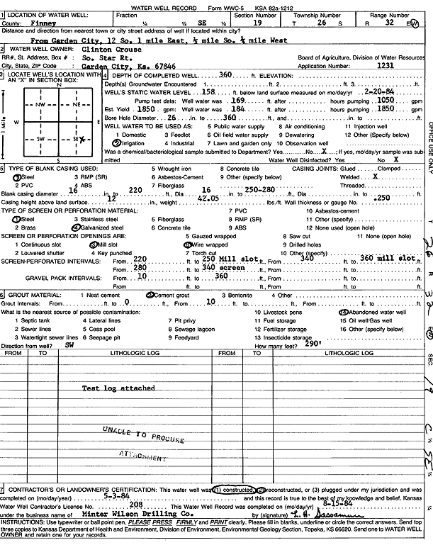
Specific Water Well Detail |
|
|
| Location Info | |||
| Owner: Crouse, Clinton | Status: Constructed | ||
| Location: T26S, R32W, Sec. 19, SE | County: Finney | ||
| Directions: from Garden City: 12 mi S, 1 mi E, 0.5 mi S, and 0.25 mi W | |||
| Latitude: 37.7695349 | Longitude: -100.8568944 | Datum NAD 27 | |
| Latitude: 37.7695587 | Longitude: -100.8573355 | Datum NAD 83 | |
| Longitude and latitude calculated by Survey from township-range-section-quarter calls. Only good to within the quarter call accuracy. | |||
| View well on interactive map | |||
| General Info | ||
| Well Depth: 360 ft. | Elevation: ft. | |
| Static Water Level: 158 ft. | Est. Yield: 1850 gpm. | |
| Comp. Date: 03-May-1984 | Well Use: Irrigation | |
| DWR Applic. #: 1231 | Other ID: | |
| Links | |
| View info from Wizard Water Level Data base... | |
| View info from WIMAS Water Right Data base... | |
| Driller Info | ||
| Driller: Minter-Wilson Drlg. Co., Inc. | License #: 208 | |
| Scanned Form | View scan |
|
Chemical Sample Submitted?: No
Water Well disinfected?: | ||
| Ground water encountered: 0 ft. , 0 ft. , 0 ft. | ||
| Pump test data: Well water was 169 ft after 0 hours pumping 1050 gpm | ||
| Casing Info | ||
| Casing Type: Steel
Casing Joints: |
Diam: 16 in. to 220 ft
Diam: 16 in. to 250 ft Diam: 0 in. to 0 ft | |
| Casing height above land surface: in
Casing Weight: lbs/ft Wall thickness or gauge no.: | ||
| Screen and Perforation Info | ||
| Screen Type: Steel | Screen Openings: Mill slot | |
| Screen-perforated intervals | From: 220 ft to 250 ft
From: 340 ft to 360 ft From: 280 ft to 340 ft | |
| Gravel pack intervals | From: ft to ft | |
| Grout Info | ||
| Grout used: Cement grout | From: 0 to 10 ft
From: 0 to 0 ft From: 0 to 0 ft | |
| Source of Possible Contamination | ||
| Source: Abandoned water well | ||
| Direction from well: | Distance: 0 ft | |
| Lithologic Log
(log data not edited or checked by the KGS.) | ||
| From: 0 ft. to 4 ft. | Type: CLAY | |
| From: 4 ft. to 40 ft. | Type: SANDY CLAY | |
| From: 40 ft. to 67 ft. | Type: FINE SAND | |
| From: 67 ft. to 70 ft. | Type: SANDY CLAY | |
| From: 70 ft. to 130 ft. | Type: SAND & GRAVEL | |
| From: 130 ft. to 152 ft. | Type: SANDY CLAY | |
| From: 152 ft. to 190 ft. | Type: SAND & GRAVEL | |
| From: 190 ft. to 196 ft. | Type: SANDY CLAY | |
| From: 196 ft. to 252 ft. | Type: SAND & GRAVEL | |
| From: 252 ft. to 280 ft. | Type: SANDY CLAY | |
| From: 280 ft. to 347 ft. | Type: SAND & GRAVEL | |
| From: 347 ft. to 351 ft. | Type: CLAY | |
| From: 351 ft. to 360 ft. | Type: SAND & GRAVEL | |
| From: 360 ft. to 395 ft. | Type: SANDY CLAY | |
| From: 395 ft. to 431 ft. | Type: CLAY | |
| From: 431 ft. to 440 ft. | Type: SAND & GRAVEL | |
| From: 440 ft. to 465 ft. | Type: SANDY CLAY | |