|
|
|
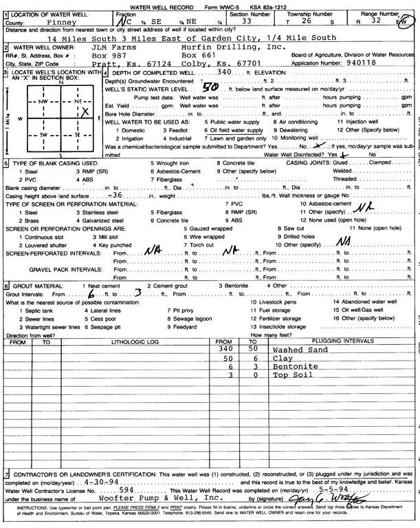
Specific Water Well Detail |
|
|
| Location Info | |||
| Owner: JLM Farms | Status: Plugged | ||
| Location: T26S, R32W, Sec. 33, C SE NE | County: Finney | ||
| Directions: from Garden City, 14 mi S, 3 mi E, and 0.25 mi S | |||
| Latitude: 37.7457777 | Longitude: -100.8181539 | Datum NAD 27 | |
| Latitude: 37.7458017 | Longitude: -100.8185936 | Datum NAD 83 | |
| Longitude and latitude calculated by Survey from township-range-section-quarter calls. Only good to within the quarter call accuracy. | |||
| View well on interactive map | |||
| General Info | ||
| Well Depth: 340 ft. | Elevation: ft. | |
| Static Water Level: 50 ft. | Est. Yield: gpm. | |
| Comp. Date: 30-Apr-1994 | Well Use: Oil Field Water Supply | |
| DWR Applic. #: 940118 | Other ID: | |
| Links | |
| No Wizard information available. | |
| View info from WIMAS Water Right Data base... | |
| Driller Info | ||
| Driller: Coranco Great Plains | License #: 594 | |
| Scanned Form | View scan |
| Casing Info | ||
|
Casing Type:
Diam: 0 in. Casing height above land surface: in | ||
| Grout Info | ||
| Grout used: Bentonite | From: 3 to 6 ft
From: 0 to 0 ft From: 0 to 0 ft | |
| Source of Possible Contamination | ||
| Source: OTHER | ||
| Direction from well: | Distance: 0 ft | |