|
|
|
Specific Water Well Detail |
|
|
| Location Info | |||
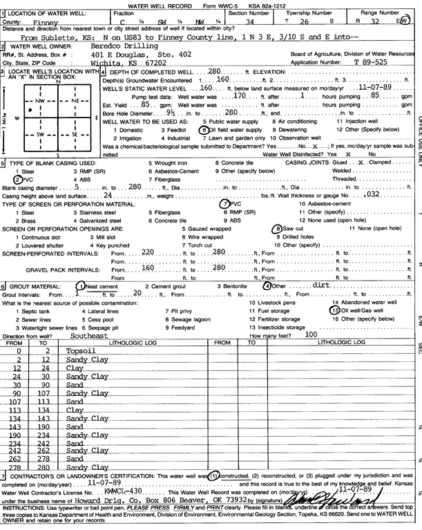
| Owner: Beredco Drilling | Status: Constructed | ||
| Location: T26S, R32W, Sec. 34, C SW NW | County: Finney | ||
| Directions: 1 mi N on Hwy 83 of S county line, 3 mi E, 0.3 mi S, and E into site | |||
| Latitude: 37.7457724 | Longitude: -100.8135743 | Datum NAD 27 | |
| Latitude: 37.7457964 | Longitude: -100.8140139 | Datum NAD 83 | |
| Longitude and latitude calculated by Survey from township-range-section-quarter calls. Only good to within the quarter call accuracy. | |||
| View well on interactive map | |||
| General Info | ||
| Well Depth: 280 ft. | Elevation: ft. | |
| Static Water Level: 160 ft. | Est. Yield: 85 gpm. | |
| Comp. Date: 07-Nov-1989 | Well Use: Oil Field Water Supply | |
| DWR Applic. #: T89-525 | Other ID: | |
| Links | |
| No Wizard information available. | |
| View info from WIMAS Water Right Data base... | |
| Driller Info | ||
| Driller: Howard Drilling Co. | License #: 430 | |
| Scanned Form | View scan |
|
Chemical Sample Submitted?: No
Water Well disinfected?: | ||
| Ground water encountered: 160 ft. , 0 ft. , 0 ft. | ||
| Pump test data: Well water was 170 ft after 1 hours pumping 85 gpm | ||
| Casing Info | ||
| Casing Type: PVC
Casing Joints: |
Diam: 5 in. to 280 ft
Diam: 0 in. to 0 ft Diam: 0 in. to 0 ft | |
| Casing height above land surface: in
Casing Weight: lbs/ft Wall thickness or gauge no.: | ||
| Screen and Perforation Info | ||
| Screen Type: PVC | Screen Openings: Saw cut | |
| Screen-perforated intervals | From: 220 ft to 280 ft
From: 0 ft to 0 ft From: 0 ft to 0 ft | |
| Gravel pack intervals | From: ft to ft | |
| Grout Info | ||
| Grout used: Neat cement, | From: 1 to 20 ft
From: 0 to 0 ft From: 0 to 0 ft | |
| Source of Possible Contamination | ||
| Source: Oil well/gas well | ||
| Direction from well: | Distance: 0 ft | |
| Lithologic Log
(Log data entered by KGS.) | ||
| From: 0 ft. to 2 ft. | topsoil | |
| From: 2 ft. to 12 ft. | sandy clay | |
| From: 12 ft. to 24 ft. | clay | |
| From: 24 ft. to 30 ft. | sandy clay | |
| From: 30 ft. to 90 ft. | sand | |
| From: 90 ft. to 107 ft. | sandy clay | |
| From: 107 ft. to 113 ft. | sand | |
| From: 113 ft. to 134 ft. | clay | |
| From: 134 ft. to 143 ft. | sandy clay | |
| From: 143 ft. to 190 ft. | sand | |
| From: 190 ft. to 234 ft. | sandy clay | |
| From: 234 ft. to 242 ft. | sand | |
| From: 242 ft. to 262 ft. | sandy clay | |
| From: 262 ft. to 278 ft. | sand | |
| From: 278 ft. to 280 ft. | sandy clay | |