|
|
|
Specific Water Well Detail |
|
|
| Location Info | |||
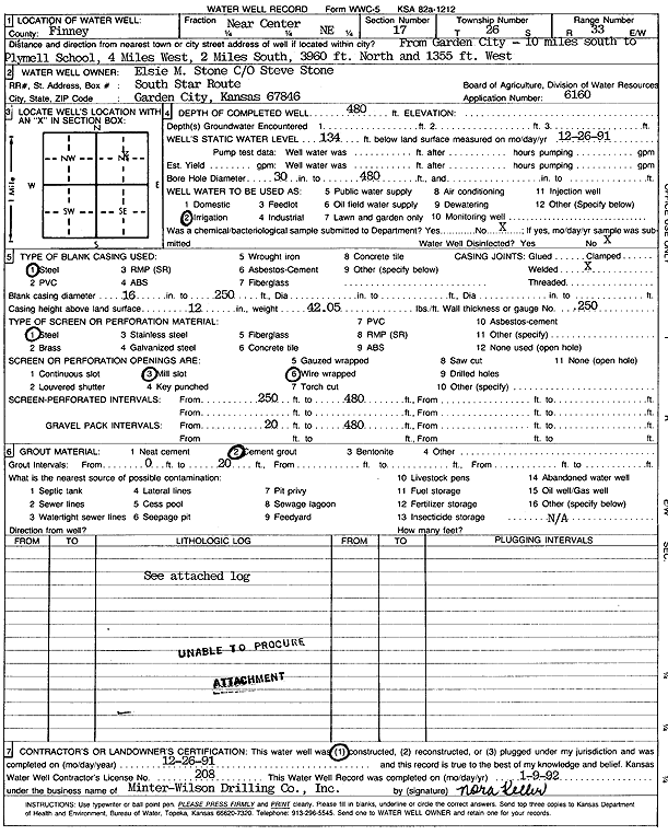
| Owner: Stone, Elsie M. | Status: Constructed | ||
| Location: T26S, R33W, Sec. 17, NC NE | County: Finney | ||
| Directions: from Plymell school: 4 mi W, 2 mi S, 3960 feet N, 1355 feet W | |||
| Latitude: 37.7931342 | Longitude: -100.9479558 | Datum NAD 27 | |
| Latitude: 37.7931579 | Longitude: -100.9484001 | Datum NAD 83 | |
| Longitude and latitude calculated by Survey from township-range-section-quarter calls. Only good to within the quarter call accuracy. | |||
| View well on interactive map | |||
| General Info | ||
| Well Depth: 480 ft. | Elevation: ft. | |
| Static Water Level: 134 ft. | Est. Yield: gpm. | |
| Comp. Date: 26-Dec-1991 | Well Use: Irrigation | |
| DWR Applic. #: 6160 | Other ID: | |
| Links | |
| No Wizard information available. | |
| View info from WIMAS Water Right Data base... | |
| Driller Info | ||
| Driller: Minter-Wilson Drlg. Co., Inc. | License #: 208 | |
| Scanned Form | View scan |
|
Chemical Sample Submitted?: No
Water Well disinfected?: | ||
| Ground water encountered: 0 ft. , 0 ft. , 0 ft. | ||
| Pump test data: Well water was 0 ft after 0 hours pumping 0 gpm | ||
| Casing Info | ||
| Casing Type: Steel
Casing Joints: |
Diam: 16 in. to 250 ft
Diam: 0 in. to 0 ft Diam: 0 in. to 0 ft | |
| Casing height above land surface: in
Casing Weight: lbs/ft Wall thickness or gauge no.: | ||
| Screen and Perforation Info | ||
| Screen Type: Steel | Screen Openings: Wire wrapped | |
| Screen-perforated intervals | From: 250 ft to 480 ft
From: 0 ft to 0 ft From: 0 ft to 0 ft | |
| Gravel pack intervals | From: ft to ft | |
| Grout Info | ||
| Grout used: Cement grout | From: 0 to 20 ft
From: 0 to 0 ft From: 0 to 0 ft | |
| Source of Possible Contamination | ||
| Source: OTHER | ||
| Direction from well: | Distance: 0 ft | |
| Lithologic Log
(log data not edited or checked by the KGS.) | ||
| From: 0 ft. to 18 ft. | Type: CLAY | |
| From: 18 ft. to 42 ft. | Type: SAND & GRAVEL | |
| From: 42 ft. to 59 ft. | Type: SANDY CLAY | |
| From: 59 ft. to 91 ft. | Type: SAND & GRAVEL | |
| From: 91 ft. to 95 ft. | Type: CLAY | |
| From: 95 ft. to 104 ft. | Type: SAND & GRAVEL | |
| From: 104 ft. to 110 ft. | Type: ROCK & CLAY | |
| From: 110 ft. to 135 ft. | Type: SAND & GRAVEL | |
| From: 135 ft. to 142 ft. | Type: SANDY CLAY | |
| From: 142 ft. to 148 ft. | Type: SAND & GRAVEL | |
| From: 148 ft. to 157 ft. | Type: SANDY CLAY | |
| From: 157 ft. to 231 ft. | Type: SAND & GRAVEL | |
| From: 231 ft. to 241 ft. | Type: SANDY CLAY | |
| From: 241 ft. to 265 ft. | Type: SAND & GRAVEL | |
| From: 265 ft. to 275 ft. | Type: SANDY CLAY | |
| From: 275 ft. to 304 ft. | Type: SAND & GRAVEL | |
| From: 304 ft. to 339 ft. | Type: SANDY CLAY | |
| From: 339 ft. to 344 ft. | Type: FINE SAND | |
| From: 344 ft. to 349 ft. | Type: SANDY CLAY | |
| From: 349 ft. to 376 ft. | Type: SAND & GRAVEL | |
| From: 376 ft. to 427 ft. | Type: SANDY CLAY | |
| From: 427 ft. to 443 ft. | Type: SAND & GRAVEL | |
| From: 443 ft. to 472 ft. | Type: CLAY | |
| From: 472 ft. to 476 ft. | Type: SAND & GRAVEL | |
| From: 476 ft. to 485 ft. | Type: SHALE | |