|
|
|
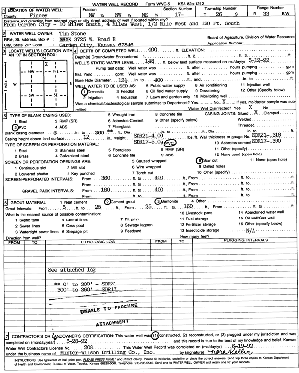
Specific Water Well Detail |
|
|
| Location Info | |||
| Owner: Stone, Tim | Status: Constructed | ||
| Location: T26S, R33W, Sec. 17, NW NW NE | County: Finney | ||
| Directions: from Garden City: 10 mi S, 4 mi W, 0.5 mi W, and 120 feet S | |||
| Latitude: 37.7940304 | Longitude: -100.9513741 | Datum NAD 27 | |
| Latitude: 37.7940541 | Longitude: -100.9518186 | Datum NAD 83 | |
| Longitude and latitude calculated by Survey from township-range-section-quarter calls. Only good to within the quarter call accuracy. | |||
| View well on interactive map | |||
| General Info | ||
| Well Depth: 400 ft. | Elevation: ft. | |
| Static Water Level: 148 ft. | Est. Yield: gpm. | |
| Comp. Date: 28-May-1992 | Well Use: Domestic | |
| DWR Applic. #: | Other ID: | |
| Driller Info | ||
| Driller: Minter-Wilson Drlg. Co., Inc. | License #: 208 | |
| Scanned Form | View scan |
|
Chemical Sample Submitted?: No
Water Well disinfected?: | ||
| Ground water encountered: 0 ft. , 0 ft. , 0 ft. | ||
| Pump test data: Well water was 0 ft after 0 hours pumping 0 gpm | ||
| Casing Info | ||
| Casing Type: PVC
Casing Joints: |
Diam: 6 in. to 360 ft
Diam: 0 in. to 0 ft Diam: 0 in. to 0 ft | |
| Casing height above land surface: in
Casing Weight: lbs/ft Wall thickness or gauge no.: | ||
| Screen and Perforation Info | ||
| Screen Type: PVC | Screen Openings: Saw cut | |
| Screen-perforated intervals | From: 360 ft to 400 ft
From: 0 ft to 0 ft From: 0 ft to 0 ft | |
| Gravel pack intervals | From: ft to ft | |
| Grout Info | ||
| Grout used: Cement grout, Bentonite | From: 5 to 25 ft
From: 25 to 160 ft From: 0 to 0 ft | |
| Source of Possible Contamination | ||
| Source: OTHER | ||
| Direction from well: | Distance: 0 ft | |
| Lithologic Log
(log data not edited or checked by the KGS.) | ||
| From: 0 ft. to 2 ft. | Type: CLAY | |
| From: 2 ft. to 41 ft. | Type: SANDY CLAY | |
| From: 41 ft. to 63 ft. | Type: FINE SAND | |
| From: 63 ft. to 150 ft. | Type: SAND & GRAVEL | |
| From: 150 ft. to 155 ft. | Type: SANDY CLAY | |
| From: 155 ft. to 161 ft. | Type: CLAY & GRAVEL | |
| From: 161 ft. to 168 ft. | Type: SANDY CLAY | |
| From: 168 ft. to 183 ft. | Type: CLAY & GRAVEL | |
| From: 183 ft. to 190 ft. | Type: SANDY CLAY | |
| From: 190 ft. to 207 ft. | Type: CLAY | |
| From: 207 ft. to 216 ft. | Type: CLAY & GRAVEL | |
| From: 216 ft. to 231 ft. | Type: SAND & GRAVEL | |
| From: 231 ft. to 237 ft. | Type: SANDY CLAY | |
| From: 237 ft. to 253 ft. | Type: CLAY & GRAVEL | |
| From: 253 ft. to 280 ft. | Type: SANDY CLAY | |
| From: 280 ft. to 312 ft. | Type: ROCK & CLAY | |
| From: 312 ft. to 325 ft. | Type: SAND & GRAVEL | |
| From: 325 ft. to 337 ft. | Type: SANDY CLAY | |
| From: 337 ft. to 345 ft. | Type: SAND & GRAVEL | |
| From: 345 ft. to 363 ft. | Type: SANDY CLAY | |
| From: 363 ft. to 396 ft. | Type: SAND & GRAVEL | |
| From: 396 ft. to 418 ft. | Type: CLAY & GRAVEL | |
| From: 418 ft. to 460 ft. | Type: SANDY CLAY | |