|
|
|
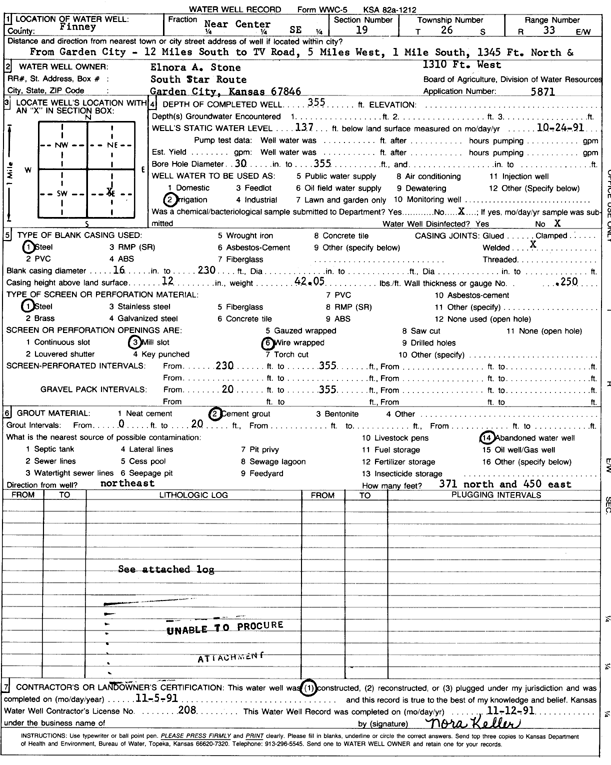
Specific Water Well Detail |
|
|
| Location Info | |||
| Owner: Stone, Elnora A. | Status: Constructed | ||
| Location: T26S, R33W, Sec. 19, NC SE | County: Finney | ||
| Directions: from Garden City: 12 mi S to TV Rd, 5 mi W, 1 mi S, 1345 feet N, 1310 feet W | |||
| Latitude: 37.771285 | Longitude: -100.9662997 | Datum NAD 27 | |
| Latitude: 37.7713088 | Longitude: -100.966745 | Datum NAD 83 | |
| Longitude and latitude calculated by Survey from township-range-section-quarter calls. Only good to within the quarter call accuracy. | |||
| View well on interactive map | |||
| General Info | ||
| Well Depth: 355 ft. | Elevation: ft. | |
| Static Water Level: 137 ft. | Est. Yield: gpm. | |
| Comp. Date: 05-Nov-1991 | Well Use: Irrigation | |
| DWR Applic. #: 5871 | Other ID: | |
| Links | |
| No Wizard information available. | |
| View info from WIMAS Water Right Data base... | |
| Driller Info | ||
| Driller: Minter-Wilson Drlg. Co., Inc. | License #: 208 | |
| Scanned Form | View scan |
|
Chemical Sample Submitted?: No
Water Well disinfected?: | ||
| Ground water encountered: 0 ft. , 0 ft. , 0 ft. | ||
| Pump test data: Well water was 0 ft after 0 hours pumping 0 gpm | ||
| Casing Info | ||
| Casing Type: Steel
Casing Joints: |
Diam: 16 in. to 230 ft
Diam: 0 in. to 0 ft Diam: 0 in. to 0 ft | |
| Casing height above land surface: in
Casing Weight: lbs/ft Wall thickness or gauge no.: | ||
| Screen and Perforation Info | ||
| Screen Type: Steel | Screen Openings: Mill slot | |
| Screen-perforated intervals | From: 230 ft to 355 ft
From: 0 ft to 0 ft From: 0 ft to 0 ft | |
| Gravel pack intervals | From: ft to ft | |
| Grout Info | ||
| Grout used: Cement grout | From: 0 to 20 ft
From: 0 to 0 ft From: 0 to 0 ft | |
| Source of Possible Contamination | ||
| Source: Abandoned water well | ||
| Direction from well: | Distance: 0 ft | |
| Lithologic Log
(log data not edited or checked by the KGS.) | ||
| From: 0 ft. to 3 ft. | Type: CLAY | |
| From: 3 ft. to 47 ft. | Type: SANDY CLAY | |
| From: 47 ft. to 116 ft. | Type: SAND & GRAVEL | |
| From: 116 ft. to 127 ft. | Type: CLAY | |
| From: 127 ft. to 164 ft. | Type: SAND & GRAVEL | |
| From: 164 ft. to 197 ft. | Type: SAND & GRAVEL | |
| From: 197 ft. to 206 ft. | Type: CLAY | |
| From: 206 ft. to 307 ft. | Type: SAND & GRAVEL | |
| From: 307 ft. to 321 ft. | Type: CLAY | |
| From: 321 ft. to 326 ft. | Type: SAND & GRAVEL | |
| From: 326 ft. to 333 ft. | Type: CLAY | |
| From: 333 ft. to 351 ft. | Type: SAND & GRAVEL | |
| From: 351 ft. to 359 ft. | Type: CLAY | |
| From: 359 ft. to 381 ft. | Type: ROCK & CLAY | |
| From: 381 ft. to 455 ft. | Type: CLAY | |
| From: 455 ft. to 479 ft. | Type: ROCK & CLAY | |
| From: 479 ft. to 497 ft. | Type: CLAY | |
| From: 497 ft. to 500 ft. | Type: SHALE | |