|
|
|
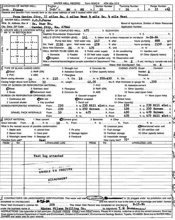
Specific Water Well Detail |
|
|
| Location Info | |||
| Owner: SCS Farms | Status: Constructed | ||
| Location: T26S, R33W, Sec. 20, SW NE | County: Finney | ||
| Directions: from Garden City: 11 mi S, 4 mi W, .5 mi S, and 0.5 mi W | |||
| Latitude: 37.7749126 | Longitude: -100.9504057 | Datum NAD 27 | |
| Latitude: 37.7749363 | Longitude: -100.9508503 | Datum NAD 83 | |
| Longitude and latitude calculated by Survey from township-range-section-quarter calls. Only good to within the quarter call accuracy. | |||
| View well on interactive map | |||
| General Info | ||
| Well Depth: 475 ft. | Elevation: ft. | |
| Static Water Level: 141 ft. | Est. Yield: 2150 gpm. | |
| Comp. Date: 26-Jun-1984 | Well Use: Irrigation | |
| DWR Applic. #: | Other ID: | |
| Links | |
| No Wizard information available. | |
| View info from WIMAS Water Right Data base... | |
| Driller Info | ||
| Driller: MW Drilling | License #: 208 | |
| Scanned Form | View scan |
|
Chemical Sample Submitted?: No
Water Well disinfected?: | ||
| Ground water encountered: 0 ft. , 0 ft. , 0 ft. | ||
| Pump test data: Well water was 147 ft after 0 hours pumping 800 gpm | ||
| Casing Info | ||
| Casing Type: Steel
Casing Joints: |
Diam: 16 in. to 210 ft
Diam: 16 in. to 350 ft Diam: 0 in. to 0 ft | |
| Casing height above land surface: in
Casing Weight: lbs/ft Wall thickness or gauge no.: | ||
| Screen and Perforation Info | ||
| Screen Type: Steel | Screen Openings: Mill slot | |
| Screen-perforated intervals | From: 210 ft to 230 ft
From: 230 ft to 230 ft From: 230 ft to 250 ft | |
| Gravel pack intervals | From: ft to ft | |
| Grout Info | ||
| Grout used: Cement grout | From: 0 to 10 ft
From: 0 to 0 ft From: 0 to 0 ft | |
| Source of Possible Contamination | ||
| Source: Abandoned water well | ||
| Direction from well: | Distance: 0 ft | |
| Lithologic Log
(log data not edited or checked by the KGS.) | ||
| From: 0 ft. to 2 ft. | Type: CLAY | |
| From: 2 ft. to 51 ft. | Type: SANDY CLAY | |
| From: 51 ft. to 111 ft. | Type: SAND & GRAVEL | |
| From: 111 ft. to 125 ft. | Type: CLAY | |
| From: 125 ft. to 176 ft. | Type: SAND & GRAVEL | |
| From: 176 ft. to 179 ft. | Type: CLAY | |
| From: 179 ft. to 248 ft. | Type: SAND & GRAVEL | |
| From: 248 ft. to 261 ft. | Type: CLAY | |
| From: 261 ft. to 306 ft. | Type: SAND & GRAVEL | |
| From: 306 ft. to 316 ft. | Type: SANDY CLAY | |
| From: 316 ft. to 350 ft. | Type: SAND & GRAVEL | |
| From: 350 ft. to 424 ft. | Type: SANDY CLAY | |
| From: 424 ft. to 470 ft. | Type: SAND & GRAVEL | |
| From: 470 ft. to 472 ft. | Type: CLAY & GRAVEL | |
| From: 472 ft. to 480 ft. | Type: CLAY | |
| From: 480 ft. to 485 ft. | Type: SHALE | |