|
|
|
Specific Water Well Detail |
|
|
| Location Info | |||
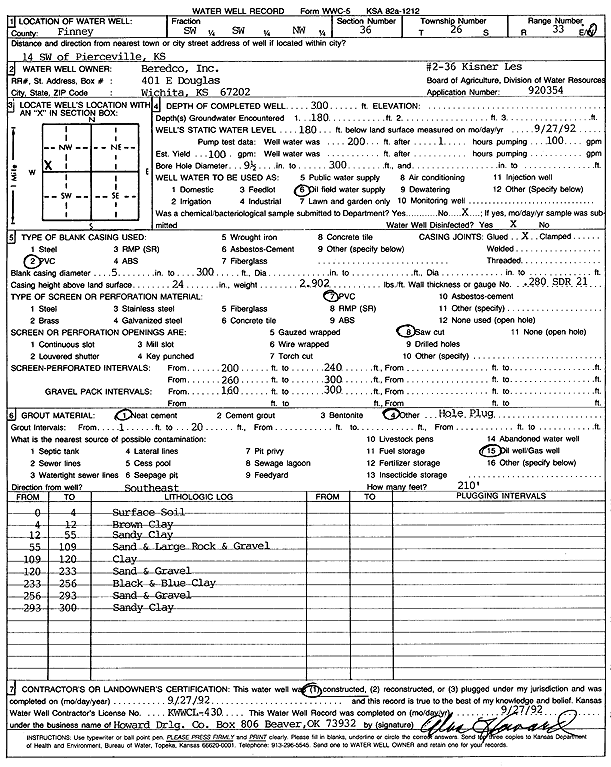
| Owner: Beredco, Inc. | Status: Constructed | ||
| Location: T26S, R33W, Sec. 36, SW SW NW | County: Finney | ||
| Directions: from Pierceville, 14 mi SW | |||
| Latitude: 37.7449628 | Longitude: -100.8875483 | Datum NAD 27 | |
| Latitude: 37.7449867 | Longitude: -100.8879908 | Datum NAD 83 | |
| Longitude and latitude calculated by Survey from township-range-section-quarter calls. Only good to within the quarter call accuracy. | |||
| View well on interactive map | |||
| General Info | ||
| Well Depth: 300 ft. | Elevation: ft. | |
| Static Water Level: 180 ft. | Est. Yield: 100 gpm. | |
| Comp. Date: 27-Sep-1992 | Well Use: Oil Field Water Supply | |
| DWR Applic. #: 920354 | Other ID: | |
| Links | |
| No Wizard information available. | |
| View info from WIMAS Water Right Data base... | |
| Driller Info | ||
| Driller: Howard Drilling Co. | License #: 430 | |
| Scanned Form | View scan |
|
Chemical Sample Submitted?: No
Water Well disinfected?: | ||
| Ground water encountered: 180 ft. , 0 ft. , 0 ft. | ||
| Pump test data: Well water was 0 ft after 0 hours pumping 0 gpm | ||
| Casing Info | ||
| Casing Type: PVC
Casing Joints: |
Diam: 5 in. to 300 ft
Diam: 0 in. to 0 ft Diam: 0 in. to 0 ft | |
| Casing height above land surface: in
Casing Weight: lbs/ft Wall thickness or gauge no.: | ||
| Screen and Perforation Info | ||
| Screen Type: PVC | Screen Openings: Saw cut | |
| Screen-perforated intervals | From: 200 ft to 240 ft
From: 0 ft to 0 ft From: 0 ft to 0 ft | |
| Gravel pack intervals | From: ft to ft | |
| Grout Info | ||
| Grout used: Neat cement, | From: 1 to 20 ft
From: 0 to 0 ft From: 0 to 0 ft | |
| Source of Possible Contamination | ||
| Source: Oil well/gas well | ||
| Direction from well: | Distance: 0 ft | |
| Lithologic Log
(Log data entered by KGS.) | ||
| From: 0 ft. to 4 ft. | surface soil | |
| From: 4 ft. to 12 ft. | brown clay | |
| From: 12 ft. to 55 ft. | sandy clay | |
| From: 55 ft. to 109 ft. | sand and large rock and gravel | |
| From: 109 ft. to 120 ft. | clay | |
| From: 120 ft. to 233 ft. | sand and gravel | |
| From: 233 ft. to 256 ft. | black and blue clay | |
| From: 256 ft. to 293 ft. | sand and gravel | |
| From: 293 ft. to 300 ft. | sandy clay | |