|
|
|
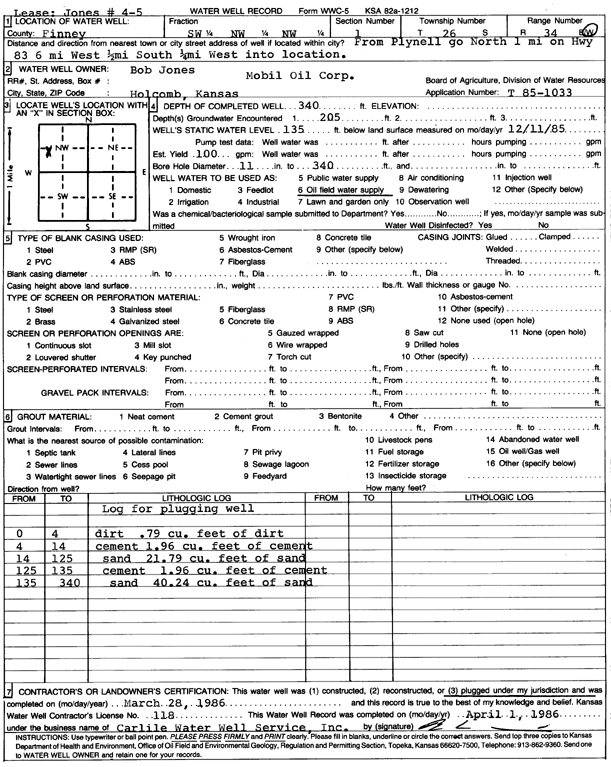
Specific Water Well Detail |
|
|
| Location Info | |||
| Owner: Mobil Oil Corp./Bob Jones | Status: Plugged | ||
| Location: T26S, R34W, Sec. 1, SW NW NW | County: Finney | ||
| Directions: from Plymell: 1 mi N on Hwy 83, 6 mi W, 0.5 mi S, 0.25 mi W into site | |||
| Latitude: 37.8256401 | Longitude: -100.997006 | Datum NAD 27 | |
| Latitude: 37.825664 | Longitude: -100.997452 | Datum NAD 83 | |
| Longitude and latitude calculated by Survey from township-range-section-quarter calls. Only good to within the quarter call accuracy. | |||
| View well on interactive map | |||
| General Info | ||
| Well Depth: 340 ft. | Elevation: ft. | |
| Static Water Level: 135 ft. | Est. Yield: 100 gpm. | |
| Comp. Date: 28-Mar-1986 | Well Use: Oil Field Water Supply | |
| DWR Applic. #: T85-1033 | Other ID: Jones 4-5 | |
| Driller Info | ||
| Driller: Bernard E. Carlile Water Well Service, Inc. | License #: 118 | |
| Scanned Form | View scan |
| Casing Info | ||
|
Casing Type:
Diam: 0 in. Casing height above land surface: in | ||
| Grout Info | ||
| Grout used: | From: 0 to 0 ft
From: 0 to 0 ft From: 0 to 0 ft | |
| Source of Possible Contamination | ||
| Source: | ||
| Direction from well: | Distance: 0 ft | |