|
|
|
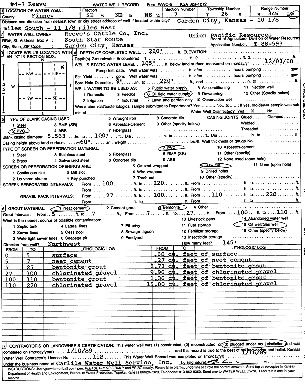
Specific Water Well Detail |
|
|
| Location Info | |||
| Owner: Reeve's Cattle Co., Inc. | Status: Plugged | ||
| Location: T26S, R34W, Sec. 7, SE NE NE | County: Finney | ||
| Directions: from Garden City: 10.13 mi S and 11.13 mi W | |||
| Latitude: 37.8064238 | Longitude: -101.0728897 | Datum NAD 27 | |
| Latitude: 37.8064461 | Longitude: -101.0733368 | Datum NAD 83 | |
| Longitude and latitude calculated by Survey from township-range-section-quarter calls. Only good to within the quarter call accuracy. | |||
| View well on interactive map | |||
| General Info | ||
| Well Depth: 220 ft. | Elevation: ft. | |
| Static Water Level: 185 ft. | Est. Yield: gpm. | |
| Comp. Date: 10-Jan-1989 | Well Use: Oil Field Water Supply | |
| DWR Applic. #: T88-593 | Other ID: Reeve 4-7 | |
| Links | |
| No Wizard information available. | |
| View info from WIMAS Water Right Data base... | |
| Driller Info | ||
| Driller: Bernard E. Carlile Water Well Service, Inc. | License #: 118 | |
| Scanned Form | View scan |
| Casing Info | ||
|
Casing Type: PVC
Diam: 5 in. Casing height above land surface: in | ||
| Grout Info | ||
| Grout used: Neat cement, Bentonite | From: 5 to 7 ft
From: 7 to 27 ft From: 100 to 110 ft | |
| Source of Possible Contamination | ||
| Source: Oil well/gas well | ||
| Direction from well: | Distance: 0 ft | |