|
|
|
Specific Water Well Detail |
|
|
| Location Info | |||
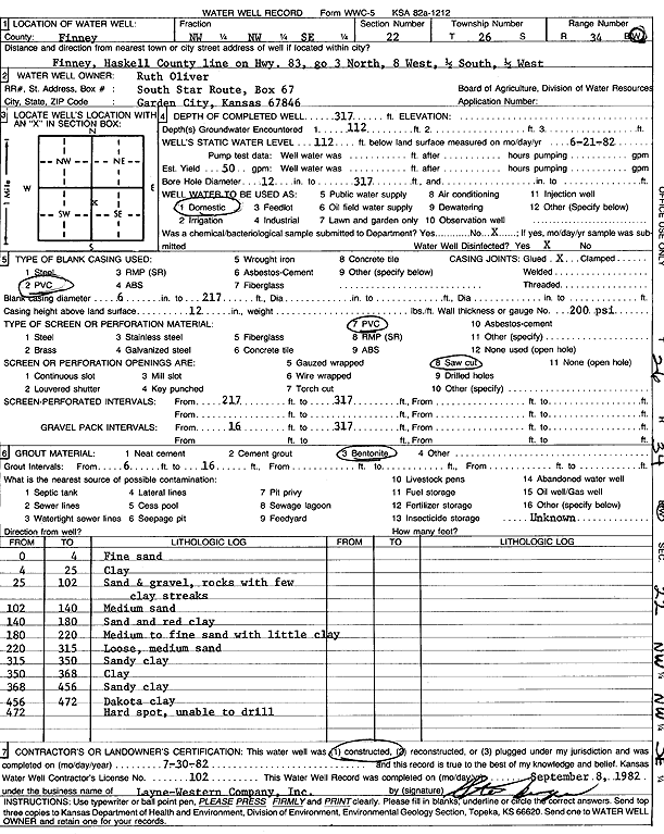
| Owner: Oliver, Ruth | Status: Constructed | ||
| Location: T26S, R34W, Sec. 22, NW NW SE | County: Finney | ||
| Directions: from Finney/Haskell County line on Hwy 83: 3 mi N, 8 mi W, 0.5 mi S, and 0.5 mi W | |||
| Latitude: 37.7721204 | Longitude: -101.024429 | Datum NAD 27 | |
| Latitude: 37.7721437 | Longitude: -101.0248759 | Datum NAD 83 | |
| Longitude and latitude calculated by Survey from township-range-section-quarter calls. Only good to within the quarter call accuracy. | |||
| View well on interactive map | |||
| General Info | ||
| Well Depth: 317 ft. | Elevation: ft. | |
| Static Water Level: 112 ft. | Est. Yield: 50 gpm. | |
| Comp. Date: 30-Jul-1982 | Well Use: Domestic | |
| DWR Applic. #: | Other ID: | |
| Links | |
| No Wizard information available. | |
| View info from WIMAS Water Right Data base... | |
| Driller Info | ||
| Driller: Layne-Christensen Co. | License #: 102 | |
| Scanned Form | View scan |
|
Chemical Sample Submitted?: No
Water Well disinfected?: | ||
| Ground water encountered: 0 ft. , 0 ft. , 0 ft. | ||
| Pump test data: Well water was 0 ft after 0 hours pumping 0 gpm | ||
| Casing Info | ||
| Casing Type:
Casing Joints: |
Diam: 0 in. to 0 ft
Diam: 0 in. to 0 ft Diam: 0 in. to 0 ft | |
| Casing height above land surface: in
Casing Weight: lbs/ft Wall thickness or gauge no.: | ||
| Screen and Perforation Info | ||
| Screen Type: | Screen Openings: | |
| Screen-perforated intervals | From: 217 ft to 317 ft
From: 0 ft to 0 ft From: 0 ft to 0 ft | |
| Gravel pack intervals | From: ft to ft | |
| Grout Info | ||
| Grout used: | From: 0 to 0 ft
From: 0 to 0 ft From: 0 to 0 ft | |
| Source of Possible Contamination | ||
| Source: | ||
| Direction from well: | Distance: 0 ft | |
| Lithologic Log
(Log data entered by KGS.) | ||
| From: 0 ft. to 4 ft. | fine sand | |
| From: 4 ft. to 25 ft. | clay | |
| From: 25 ft. to 102 ft. | sand and gravel, rocks with few clay streaks | |
| From: 102 ft. to 140 ft. | medium sand | |
| From: 140 ft. to 180 ft. | sand and red clay | |
| From: 180 ft. to 220 ft. | medium to fine sand with little clay | |
| From: 220 ft. to 315 ft. | loose, medium sand | |
| From: 315 ft. to 350 ft. | sandy clay | |
| From: 350 ft. to 368 ft. | clay | |
| From: 368 ft. to 456 ft. | sandy clay | |
| From: 456 ft. to 472 ft. | Dakota clay | |