|
|
|
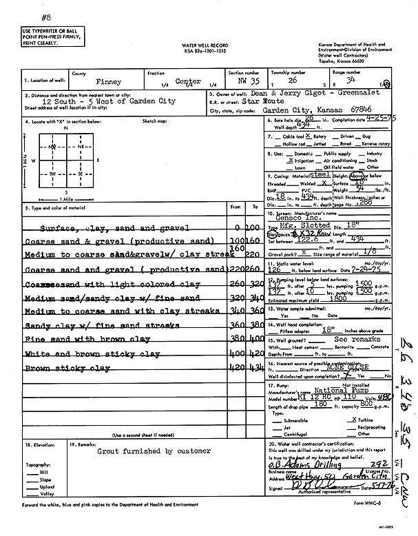
Specific Water Well Detail |
|
|
| Location Info | |||
| Owner: Gigot, Dean and Jerry | Status: Constructed | ||
| Location: T26S, R34W, Sec. 35, C NW | County: Finney | ||
| Directions: from Garden City, 12 mi S and 5 mi W | |||
| Latitude: 37.7477 | Longitude: -101.0118563 | Datum NAD 27 | |
| Latitude: 37.7477235 | Longitude: -101.0123032 | Datum NAD 83 | |
| Longitude and latitude calculated by Survey from township-range-section-quarter calls. Only good to within the quarter call accuracy. | |||
| View well on interactive map | |||
| General Info | ||
| Well Depth: 434 ft. | Elevation: ft. | |
| Static Water Level: 126 ft. | Est. Yield: 1800 gpm. | |
| Comp. Date: 25-Apr-1975 | Well Use: Irrigation | |
| DWR Applic. #: | Other ID: | |
| Links | |
| View info from Wizard Water Level Data base... | |
| View info from WIMAS Water Right Data base... | |
| Driller Info | ||
| Driller: O.B. Adams Drilling Co. | License #: 292 | |
| Scanned Form | View scan |
|
Chemical Sample Submitted?: No
Water Well disinfected?: | ||
| Ground water encountered: 0 ft. , 0 ft. , 0 ft. | ||
| Pump test data: Well water was 0 ft after 0 hours pumping 0 gpm | ||
| Casing Info | ||
| Casing Type:
Casing Joints: |
Diam: 0 in. to 0 ft
Diam: 0 in. to 0 ft Diam: 0 in. to 0 ft | |
| Casing height above land surface: in
Casing Weight: lbs/ft Wall thickness or gauge no.: | ||
| Screen and Perforation Info | ||
| Screen Type: | Screen Openings: | |
| Screen-perforated intervals | From: 123 ft to 434 ft
From: 0 ft to 0 ft From: 0 ft to 0 ft | |
| Gravel pack intervals | From: ft to ft | |
| Grout Info | ||
| Grout used: | From: 0 to 0 ft
From: 0 to 0 ft From: 0 to 0 ft | |
| Source of Possible Contamination | ||
| Source: | ||
| Direction from well: | Distance: 0 ft | |
| Lithologic Log
(Log data entered by KGS.) | ||
| From: 0 ft. to 100 ft. | surface, clay, sand and gravel | |
| From: 100 ft. to 160 ft. | coarse sand and gravel (productive sand) | |
| From: 160 ft. to 220 ft. | medium to coarse sand and gravel with clay streak | |
| From: 220 ft. to 260 ft. | coarse sand and gravel (productive sand) | |
| From: 260 ft. to 320 ft. | coarse sand with light colored clay | |
| From: 320 ft. to 340 ft. | medium sand / sandy clay with fine sand | |
| From: 340 ft. to 360 ft. | medium to coarse sand with clay streaks | |
| From: 360 ft. to 380 ft. | sandy clay with fine sand streaks | |
| From: 380 ft. to 400 ft. | fine sand with brown clay | |
| From: 400 ft. to 420 ft. | white and brown sticky clay | |
| From: 420 ft. to 434 ft. | brown sticky clay | |