|
|
|
Specific Water Well Detail |
|
|
| Location Info | |||
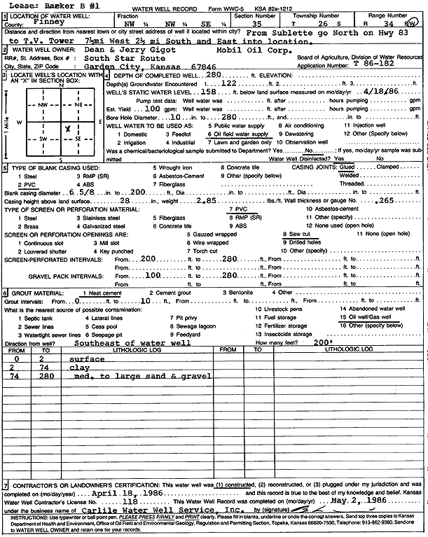
| Owner: Gigot, Dean and Jerry | Status: Constructed | ||
| Location: T26S, R34W, Sec. 35, NW NW SE | County: Finney | ||
| Directions: N of Sublette on Hwy 83 to TV tower, 7.5 mi W, 2.5 mi S, E to site | |||
| Latitude: 37.7431463 | Longitude: -101.0060006 | Datum NAD 27 | |
| Latitude: 37.7431698 | Longitude: -101.0064474 | Datum NAD 83 | |
| Longitude and latitude calculated by Survey from township-range-section-quarter calls. Only good to within the quarter call accuracy. | |||
| View well on interactive map | |||
| General Info | ||
| Well Depth: 280 ft. | Elevation: ft. | |
| Static Water Level: 158 ft. | Est. Yield: 100 gpm. | |
| Comp. Date: 18-Apr-1986 | Well Use: Oil Field Water Supply | |
| DWR Applic. #: T86-182 | Other ID: Barker B 1 | |
| Driller Info | ||
| Driller: Bernard E. Carlile Water Well Service, Inc. | License #: 118 | |
| Scanned Form | View scan |
|
Chemical Sample Submitted?: No
Water Well disinfected?: | ||
| Ground water encountered: 122 ft. , 0 ft. , 0 ft. | ||
| Pump test data: Well water was 0 ft after 0 hours pumping 0 gpm | ||
| Casing Info | ||
| Casing Type: PVC
Casing Joints: |
Diam: 6 in. to 200 ft
Diam: 0 in. to 0 ft Diam: 0 in. to 0 ft | |
| Casing height above land surface: in
Casing Weight: lbs/ft Wall thickness or gauge no.: | ||
| Screen and Perforation Info | ||
| Screen Type: PVC | Screen Openings: Saw cut | |
| Screen-perforated intervals | From: 200 ft to 280 ft
From: 0 ft to 0 ft From: 0 ft to 0 ft | |
| Gravel pack intervals | From: ft to ft | |
| Grout Info | ||
| Grout used: Neat cement | From: 0 to 10 ft
From: 0 to 0 ft From: 0 to 0 ft | |
| Source of Possible Contamination | ||
| Source: Oil well/gas well | ||
| Direction from well: | Distance: 0 ft | |
| Lithologic Log
(Log data entered by KGS.) | ||
| From: 0 ft. to 2 ft. | surface | |
| From: 2 ft. to 74 ft. | clay | |
| From: 74 ft. to 280 ft. | medium to large sand and gravel | |