|
|
|
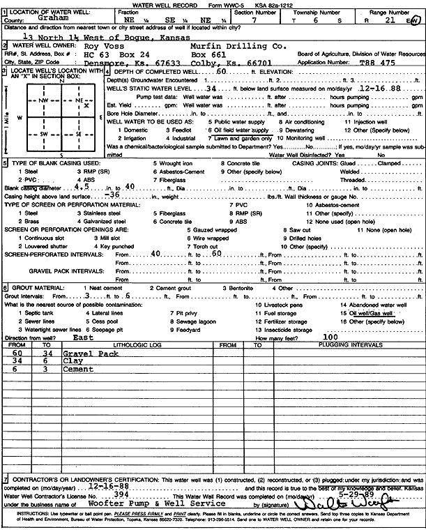
Specific Water Well Detail |
|
|
| Location Info | |||
| Owner: Roy Voss/Murfin Drilling Co. | Status: Plugged | ||
| Location: T6S, R21W, Sec. 7, NE SE NE | County: Graham | ||
| Directions: from Bogue, 13 mi N and 1.5 mi W | |||
| Latitude: 39.5487612 | Longitude: -99.6963153 | Datum NAD 27 | |
| Latitude: 39.548768 | Longitude: -99.6967067 | Datum NAD 83 | |
| Longitude and latitude calculated by Survey from township-range-section-quarter calls. Only good to within the quarter call accuracy. | |||
| View well on interactive map | |||
| General Info | ||
| Well Depth: 60 ft. | Elevation: ft. | |
| Static Water Level: 34 ft. | Est. Yield: gpm. | |
| Comp. Date: 16-Dec-1988 | Well Use: Oil Field Water Supply | |
| DWR Applic. #: T88-475 | Other ID: | |
| Links | |
| No Wizard information available. | |
| View info from WIMAS Water Right Data base... | |
| Driller Info | ||
| Driller: Walter Woofter Pump & Well | License #: 394 | |
| Scanned Form | View scan |
| Casing Info | ||
|
Casing Type: PVC
Diam: 4 in. Casing height above land surface: in | ||
| Grout Info | ||
| Grout used: | From: 3 to 6 ft
From: 0 to 0 ft From: 0 to 0 ft | |
| Source of Possible Contamination | ||
| Source: Oil well/gas well | ||
| Direction from well: | Distance: 0 ft | |