|
|
|
Specific Water Well Detail |
|
|
| Location Info | |||
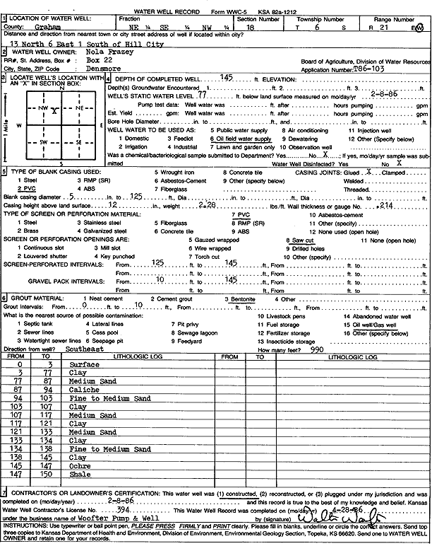
| Owner: Frazey, Nola | Status: Constructed | ||
| Location: T6S, R21W, Sec. 18, NE SE NW | County: Graham | ||
| Directions: from Hill City, 13 mi N, 6 mi E, and 1 mi S | |||
| Latitude: 39.5344052 | Longitude: -99.7051395 | Datum NAD 27 | |
| Latitude: 39.5344119 | Longitude: -99.7055314 | Datum NAD 83 | |
| Longitude and latitude calculated by Survey from township-range-section-quarter calls. Only good to within the quarter call accuracy. | |||
| View well on interactive map | |||
| General Info | ||
| Well Depth: 145 ft. | Elevation: ft. | |
| Static Water Level: 77 ft. | Est. Yield: gpm. | |
| Comp. Date: 08-Feb-1986 | Well Use: Oil Field Water Supply | |
| DWR Applic. #: T86-103 | Other ID: | |
| Driller Info | ||
| Driller: Walter Woofter Pump & Well | License #: 394 | |
| Scanned Form | View scan |
|
Chemical Sample Submitted?: No
Water Well disinfected?: | ||
| Ground water encountered: 0 ft. , 0 ft. , 0 ft. | ||
| Pump test data: Well water was 0 ft after 0 hours pumping 0 gpm | ||
| Casing Info | ||
| Casing Type: PVC
Casing Joints: |
Diam: 5 in. to 125 ft
Diam: 0 in. to 0 ft Diam: 0 in. to 0 ft | |
| Casing height above land surface: in
Casing Weight: lbs/ft Wall thickness or gauge no.: | ||
| Screen and Perforation Info | ||
| Screen Type: PVC | Screen Openings: Saw cut | |
| Screen-perforated intervals | From: 125 ft to 145 ft
From: 0 ft to 0 ft From: 0 ft to 0 ft | |
| Gravel pack intervals | From: ft to ft | |
| Grout Info | ||
| Grout used: Bentonite | From: 0 to 10 ft
From: 0 to 0 ft From: 0 to 0 ft | |
| Source of Possible Contamination | ||
| Source: Oil well/gas well | ||
| Direction from well: | Distance: 0 ft | |
| Lithologic Log
(Log data entered by KGS.) | ||
| From: 0 ft. to 3 ft. | surface | |
| From: 3 ft. to 77 ft. | clay | |
| From: 77 ft. to 87 ft. | medium sand | |
| From: 87 ft. to 94 ft. | caliche | |
| From: 94 ft. to 103 ft. | fine to medium sand | |
| From: 103 ft. to 107 ft. | clay | |
| From: 107 ft. to 117 ft. | medium sand | |
| From: 117 ft. to 121 ft. | clay | |
| From: 121 ft. to 133 ft. | medium sand | |
| From: 133 ft. to 134 ft. | clay | |
| From: 134 ft. to 138 ft. | fine to medium sand | |
| From: 138 ft. to 145 ft. | clay | |
| From: 145 ft. to 147 ft. | ochre | |
| From: 147 ft. to 150 ft. | shale | |