|
|
|
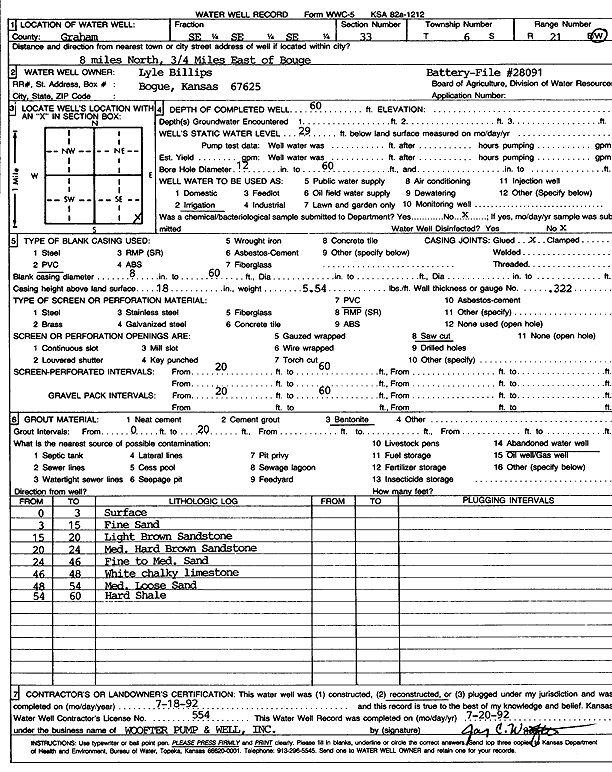
Specific Water Well Detail |
|
|
| Location Info | |||
| Owner: Billips, Lyle | Status: Reconstructed | ||
| Location: T6S, R21W, Sec. 33, SE SE SE | County: Graham | ||
| Directions: from Bogue, 8 mi N and .75 mi E | |||
| Latitude: 39.4818593 | Longitude: -99.658638 | Datum NAD 27 | |
| Latitude: 39.4818665 | Longitude: -99.6590279 | Datum NAD 83 | |
| Longitude and latitude calculated by Survey from township-range-section-quarter calls. Only good to within the quarter call accuracy. | |||
| View well on interactive map | |||
| General Info | ||
| Well Depth: 60 ft. | Elevation: ft. | |
| Static Water Level: 29 ft. | Est. Yield: gpm. | |
| Comp. Date: 18-Jul-1992 | Well Use: Irrigation | |
| DWR Applic. #: 28091 | Other ID: | |
| Links | |
| View info from Wizard Water Level Data base... | |
| View info from WIMAS Water Right Data base... | |
| Driller Info | ||
| Driller: Jay C. Woofter Pump & Well, Inc. | License #: 554 | |
| Scanned Form | View scan |
|
Chemical Sample Submitted?: No
Water Well disinfected?: | ||
| Ground water encountered: 0 ft. , 0 ft. , 0 ft. | ||
| Pump test data: Well water was 0 ft after 0 hours pumping 0 gpm | ||
| Casing Info | ||
| Casing Type: PVC
Casing Joints: |
Diam: 8 in. to 60 ft
Diam: 0 in. to 0 ft Diam: 0 in. to 0 ft | |
| Casing height above land surface: in
Casing Weight: lbs/ft Wall thickness or gauge no.: | ||
| Screen and Perforation Info | ||
| Screen Type: PVC | Screen Openings: Saw cut | |
| Screen-perforated intervals | From: 20 ft to 60 ft
From: 0 ft to 0 ft From: 0 ft to 0 ft | |
| Gravel pack intervals | From: ft to ft | |
| Grout Info | ||
| Grout used: Bentonite | From: 0 to 20 ft
From: 0 to 0 ft From: 0 to 0 ft | |
| Source of Possible Contamination | ||
| Source: Abandoned water well | ||
| Direction from well: | Distance: 0 ft | |
| Lithologic Log
(Log data entered by KGS.) | ||
| From: 0 ft. to 3 ft. | surface | |
| From: 3 ft. to 15 ft. | fine sand | |
| From: 15 ft. to 20 ft. | light brown sandstone | |
| From: 20 ft. to 24 ft. | medium hard brown sandstone | |
| From: 24 ft. to 46 ft. | fine to medium sand | |
| From: 46 ft. to 48 ft. | white chalky limestone | |
| From: 48 ft. to 54 ft. | medium sand, loose | |
| From: 54 ft. to 60 ft. | hard shale | |