|
|
|
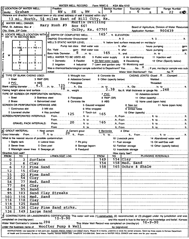
Specific Water Well Detail |
|
|
| Location Info | |||
| Owner: Murfin Drilling Co. | Status: Constructed | ||
| Location: T6S, R22W, Sec. 9, NW SE NW | County: Graham | ||
| Directions: from Hill City, 13 mi N and 5.5 mi E | |||
| Latitude: 39.5490943 | Longitude: -99.7820703 | Datum NAD 27 | |
| Latitude: 39.5491003 | Longitude: -99.7824656 | Datum NAD 83 | |
| Longitude and latitude calculated by Survey from township-range-section-quarter calls. Only good to within the quarter call accuracy. | |||
| View well on interactive map | |||
| General Info | ||
| Well Depth: 165 ft. | Elevation: ft. | |
| Static Water Level: ft. | Est. Yield: gpm. | |
| Comp. Date: 09-Oct-1990 | Well Use: Oil Field Water Supply | |
| DWR Applic. #: | Other ID: Mary Rush 9 | |
| Driller Info | ||
| Driller: Walter Woofter Pump & Well | License #: 394 | |
| Scanned Form | View scan |
|
Chemical Sample Submitted?: No
Water Well disinfected?: | ||
| Ground water encountered: 0 ft. , 0 ft. , 0 ft. | ||
| Pump test data: Well water was 0 ft after 0 hours pumping 0 gpm | ||
| Casing Info | ||
| Casing Type: PVC
Casing Joints: |
Diam: 4 in. to 129 ft
Diam: 0 in. to 0 ft Diam: 0 in. to 0 ft | |
| Casing height above land surface: in
Casing Weight: lbs/ft Wall thickness or gauge no.: | ||
| Screen and Perforation Info | ||
| Screen Type: PVC | Screen Openings: Saw cut | |
| Screen-perforated intervals | From: 125 ft to 165 ft
From: 0 ft to 0 ft From: 0 ft to 0 ft | |
| Gravel pack intervals | From: ft to ft | |
| Grout Info | ||
| Grout used: Bentonite | From: 0 to 20 ft
From: 0 to 0 ft From: 0 to 0 ft | |
| Source of Possible Contamination | ||
| Source: OTHER | ||
| Direction from well: | Distance: 0 ft | |
| Lithologic Log
(Log data entered by KGS.) | ||
| From: 0 ft. to 3 ft. | surface | |
| From: 3 ft. to 6 ft. | clay | |
| From: 6 ft. to 12 ft. | fine sand | |
| From: 12 ft. to 15 ft. | clay | |
| From: 15 ft. to 22 ft. | fine sand | |
| From: 22 ft. to 54 ft. | clay | |
| From: 54 ft. to 77 ft. | medium sand | |
| From: 77 ft. to 84 ft. | clay | |
| From: 84 ft. to 95 ft. | sand | |
| From: 95 ft. to 103 ft. | sand, clay streaks | |
| From: 103 ft. to 116 ft. | medium sand | |
| From: 116 ft. to 118 ft. | clay | |
| From: 118 ft. to 125 ft. | sand | |
| From: 125 ft. to 136 ft. | clay, fine sand streaks | |
| From: 136 ft. to 149 ft. | large sand | |
| From: 149 ft. to 154 ft. | clay | |
| From: 154 ft. to 158 ft. | medium sand | |
| From: 158 ft. to 165 ft. | ochre and shale | |