|
|
|
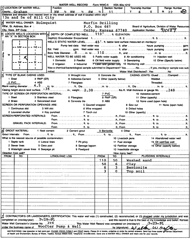
Specific Water Well Detail |
|
|
| Location Info | |||
| Owner: Murfin Drilling Co. | Status: Plugged | ||
| Location: T6S, R22W, Sec. 11, NW NW SW | County: Graham | ||
| Directions: From Hill City, 13 miles North and 5 miles East (Holmquist) | |||
| Latitude: 39.5454575 | Longitude: -99.7493446 | Datum NAD 27 | |
| Latitude: 39.5454638 | Longitude: -99.7497383 | Datum NAD 83 | |
| Longitude and latitude calculated by Survey from township-range-section-quarter calls. Only good to within the quarter call accuracy. | |||
| View well on interactive map | |||
| General Info | ||
| Well Depth: 110 ft. | Elevation: ft. | |
| Static Water Level: 45 ft. | Est. Yield: gpm. | |
| Comp. Date: 19-Jul-1991 | Well Use: Oil Field Water Supply | |
| DWR Applic. #: | Other ID: | |
| Links | |
| No Wizard information available. | |
| View info from WIMAS Water Right Data base... | |
| Driller Info | ||
| Driller: Walter Woofter Pump & Well | License #: 394 | |
| Scanned Form | View scan |
| Casing Info | ||
|
Casing Type: PVC
Diam: 4 in. Casing height above land surface: in | ||
| Grout Info | ||
| Grout used: Bentonite | From: 3 to 6 ft
From: 0 to 0 ft From: 0 to 0 ft | |
| Source of Possible Contamination | ||
| Source: Oil well/gas well | ||
| Direction from well: | Distance: 0 ft | |