|
|
|
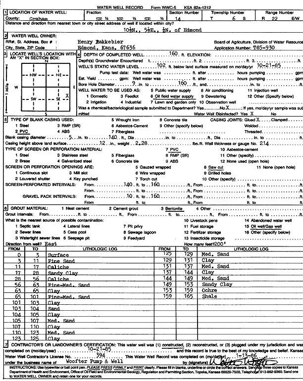
Specific Water Well Detail |
|
|
| Location Info | |||
| Owner: Pakkabier, Henry | Status: Constructed | ||
| Location: T6S, R22W, Sec. 14, SE NE SE | County: Graham | ||
| Directions: from Edmond, 10.5 mi N, 5.5 mi E, and 0.25 mi N | |||
| Latitude: 39.5291033 | Longitude: -99.7326367 | Datum NAD 27 | |
| Latitude: 39.5291097 | Longitude: -99.7330298 | Datum NAD 83 | |
| Longitude and latitude calculated by Survey from township-range-section-quarter calls. Only good to within the quarter call accuracy. | |||
| View well on interactive map | |||
| General Info | ||
| Well Depth: 160 ft. | Elevation: ft. | |
| Static Water Level: 102 ft. | Est. Yield: gpm. | |
| Comp. Date: 21-Oct-1985 | Well Use: Oil Field Water Supply | |
| DWR Applic. #: T85-930 | Other ID: | |
| Driller Info | ||
| Driller: Walter Woofter Pump & Well | License #: 394 | |
| Scanned Form | View scan |
|
Chemical Sample Submitted?:
Water Well disinfected?: | ||
| Ground water encountered: 0 ft. , 0 ft. , 0 ft. | ||
| Pump test data: Well water was 0 ft after 0 hours pumping 0 gpm | ||
| Casing Info | ||
| Casing Type: PVC
Casing Joints: |
Diam: 5 in. to 140 ft
Diam: 0 in. to 0 ft Diam: 0 in. to 0 ft | |
| Casing height above land surface: in
Casing Weight: lbs/ft Wall thickness or gauge no.: | ||
| Screen and Perforation Info | ||
| Screen Type: PVC | Screen Openings: Saw cut | |
| Screen-perforated intervals | From: 140 ft to 160 ft
From: 0 ft to 0 ft From: 0 ft to 0 ft | |
| Gravel pack intervals | From: ft to ft | |
| Grout Info | ||
| Grout used: Bentonite | From: 0 to 0 ft
From: 0 to 0 ft From: 0 to 0 ft | |
| Source of Possible Contamination | ||
| Source: Fuel storage | ||
| Direction from well: | Distance: 0 ft | |
| Lithologic Log
(Log data entered by KGS.) | ||
| From: 0 ft. to 3 ft. | surface | |
| From: 3 ft. to 11 ft. | fine sand | |
| From: 11 ft. to 17 ft. | caliche | |
| From: 17 ft. to 28 ft. | sandy clay | |
| From: 28 ft. to 56 ft. | caliche | |
| From: 56 ft. to 63 ft. | fine-medium sand | |
| From: 63 ft. to 65 ft. | clay | |
| From: 65 ft. to 101 ft. | fine-medium sand | |
| From: 101 ft. to 103 ft. | clay | |
| From: 103 ft. to 104 ft. | sand | |
| From: 104 ft. to 105 ft. | clay | |
| From: 105 ft. to 107 ft. | medium sand | |
| From: 107 ft. to 110 ft. | clay | |
| From: 110 ft. to 123 ft. | medium sand | |
| From: 123 ft. to 125 ft. | clay | |
| From: 125 ft. to 129 ft. | medium sand | |
| From: 129 ft. to 131 ft. | clay | |
| From: 131 ft. to 137 ft. | medium sand | |
| From: 137 ft. to 144 ft. | clay | |
| From: 144 ft. to 149 ft. | medium sand | |
| From: 149 ft. to 153 ft. | sandy clay | |
| From: 153 ft. to 159 ft. | ochre | |
| From: 159 ft. to 165 ft. | shale | |