|
|
|
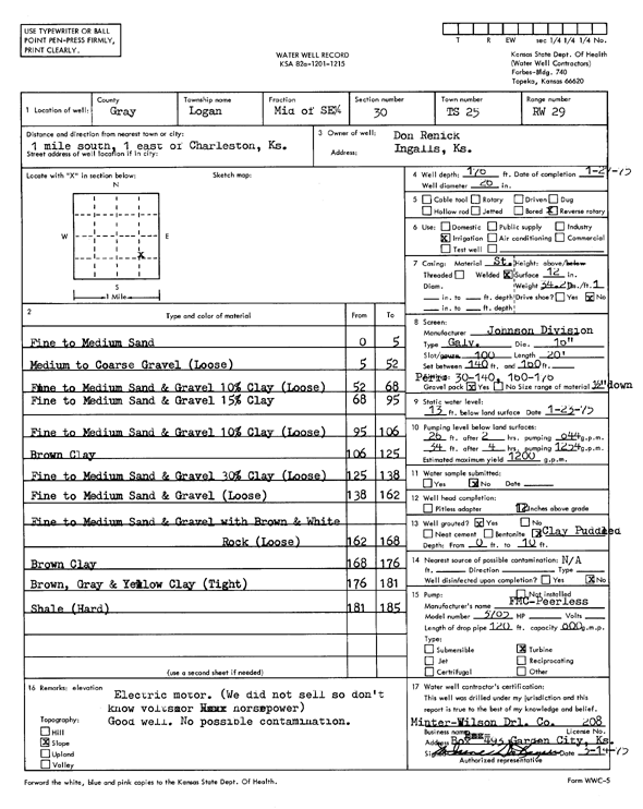
Specific Water Well Detail |
|
|
| Location Info | |||
| Owner: Renick, Don | Status: Constructed | ||
| Location: T25S, R29W, Sec. 30, C SE | County: Gray | ||
| Directions: from Charleston: 1 mi S, 1 mi E | |||
| Latitude: 37.8460219 | Longitude: -100.541689 | Datum NAD 27 | |
| Latitude: 37.8460439 | Longitude: -100.5421179 | Datum NAD 83 | |
| Longitude and latitude calculated by Survey from township-range-section-quarter calls. Only good to within the quarter call accuracy. | |||
| View well on interactive map | |||
| General Info | ||
| Well Depth: 176 ft. | Elevation: ft. | |
| Static Water Level: 13 ft. | Est. Yield: 1200 gpm. | |
| Comp. Date: 27-Jan-1975 | Well Use: Irrigation | |
| DWR Applic. #: | Other ID: | |
| Links | |
| View info from Wizard Water Level Data base... | |
| View info from WIMAS Water Right Data base... | |
| Driller Info | ||
| Driller: Minter-Wilson Drlg. Co., Inc. | License #: 208 | |
| Scanned Form | View scan |
|
Chemical Sample Submitted?: No
Water Well disinfected?: | ||
| Ground water encountered: 0 ft. , 0 ft. , 0 ft. | ||
| Pump test data: Well water was 0 ft after 0 hours pumping 0 gpm | ||
| Casing Info | ||
| Casing Type:
Casing Joints: |
Diam: 0 in. to 0 ft
Diam: 0 in. to 0 ft Diam: 0 in. to 0 ft | |
| Casing height above land surface: in
Casing Weight: lbs/ft Wall thickness or gauge no.: | ||
| Screen and Perforation Info | ||
| Screen Type: | Screen Openings: | |
| Screen-perforated intervals | From: 140 ft to 160 ft
From: 0 ft to 0 ft From: 0 ft to 0 ft | |
| Gravel pack intervals | From: ft to ft | |
| Grout Info | ||
| Grout used: | From: 0 to 0 ft
From: 0 to 0 ft From: 0 to 0 ft | |
| Source of Possible Contamination | ||
| Source: | ||
| Direction from well: | Distance: 0 ft | |
| Lithologic Log
(Log data entered by KGS.) | ||
| From: 0 ft. to 5 ft. | Fine to Medium Sand | |
| From: 5 ft. to 52 ft. | Medium to Coarse Gravel (Loose) | |
| From: 52 ft. to 68 ft. | Fine to Medium Sand and Gravel 10% Clay (Loose) | |
| From: 68 ft. to 95 ft. | Fine to Medium Sand and Gravel 15% Clay | |
| From: 95 ft. to 106 ft. | Fine to Medium Sand and Gravel 10% Clay (Loose) | |
| From: 106 ft. to 125 ft. | Brown Clay | |
| From: 125 ft. to 138 ft. | Fine to Medium Sand and Gravel 30% Clay (Loose) | |
| From: 138 ft. to 162 ft. | Fine to Medium Sand and Gravel (Loose) | |
| From: 162 ft. to 168 ft. | Fine to Medium Sand and Gravel with Brown and White Rock (Loose) | |
| From: 168 ft. to 176 ft. | Brown Clay | |
| From: 176 ft. to 181 ft. | Brown, Gray and Yellow Clay (Tight) | |
| From: 181 ft. to 185 ft. | Shale (Hard) | |