|
|
|
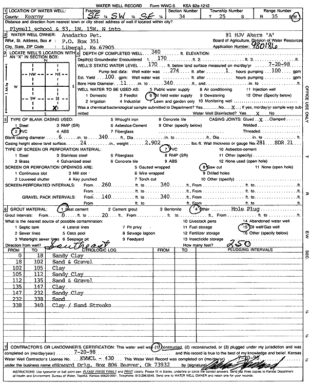
Specific Water Well Detail |
|
|
| Location Info | |||
| Owner: Anadarko Petroleum Corp. | Status: Constructed | ||
| Location: T25S, R35W, Sec. 34, SE SW SE | County: Kearny | ||
| Directions: from Plymell School and 83: 1 mi N, 15 mi W, N into site | |||
| Latitude: 37.8296314 | Longitude: -101.1455522 | Datum NAD 27 | |
| Latitude: 37.8296524 | Longitude: -101.146 | Datum NAD 83 | |
| Longitude and latitude calculated by Survey from township-range-section-quarter calls. Only good to within the quarter call accuracy. | |||
| View well on interactive map | |||
| General Info | ||
| Well Depth: 340 ft. | Elevation: ft. | |
| Static Water Level: 170 ft. | Est. Yield: 100 gpm. | |
| Comp. Date: 20-Jul-1998 | Well Use: Oil Field Water Supply | |
| DWR Applic. #: 980186 | Other ID: HJV Akers A 1 | |
| Links | |
| No Wizard information available. | |
| View info from WIMAS Water Right Data base... | |
| Driller Info | ||
| Driller: Howard Drilling Company AG, LLC | License #: 430 | |
| Scanned Form | View scan |
|
Chemical Sample Submitted?:
Water Well disinfected?: | ||
| Casing Info | ||
| Casing Type:
Casing Joints: |
Diam: in. to ft | |
| Casing height above land surface: in
Casing Weight: lbs/ft Wall thickness or gauge no.: | ||
| Screen and Perforation Info | ||
| Screen Type: | Screen Openings: | |
| Screen-perforated intervals | From: ft to ft | |
| Gravel pack intervals | From: ft to ft | |
| Grout Info | ||
| Grout used: | From: to ft | |
| Source of Possible Contamination | ||
| Source: | ||
| Direction from well: | Distance: ft | |
| Lithologic Log
(Log data entered by KGS.) | ||
| From: 0 ft. to 1 ft. | top soil | |
| From: 1 ft. to 9 ft. | brown sandy clay | |
| From: 9 ft. to 25 ft. | fine sand | |
| From: 25 ft. to 30 ft. | brown clay | |
| From: 30 ft. to 90 ft. | fine to medium sand and gravel, some coarse | |
| From: 90 ft. to 100 ft. | brown clay | |
| From: 100 ft. to 115 ft. | fine to medium sand and gravel | |
| From: 115 ft. to 134 ft. | brown clay with small gravel streaks | |
| From: 134 ft. to 193 ft. | brown and blue clay | |
| From: 193 ft. to 210 ft. | brown sandy clay | |
| From: 210 ft. to 232 ft. | fine to medium sand and gravel | |
| From: 232 ft. to 269 ft. | brown sandy clay | |
| From: 269 ft. to 281 ft. | fine to medium sand and gravel | |
| From: 281 ft. to 340 ft. | brown sandy clay | |
| From: 340 ft. to 345 ft. | fine to medium sand | |
| From: 345 ft. to 355 ft. | brown sandy clay | |
| From: 355 ft. to 360 ft. | fine to medium sand | |
| From: 360 ft. to 365 ft. | brown clay | |
| From: 365 ft. to 377 ft. | fine to medium sand, 10% clay | |
| From: 377 ft. to 400 ft. | brown clay | |
| From: 400 ft. to 412 ft. | fine to medium sand, 10% clay | |
| From: 412 ft. to 445 ft. | brown clay | |
| From: 445 ft. to 455 ft. | brown clay with 30% brown rock | |
| From: 455 ft. to 463 ft. | brown yellow clay | |
| From: 463 ft. to 485 ft. | shale, hard | |