|
|
|
Specific Water Well Detail |
|
|
| Location Info | |||
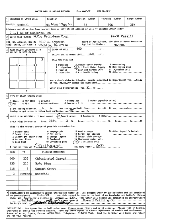
| Owner: McCoy Petroleum Corp. | Status: Plugged | ||
| Location: T30S, R31W, Sec. 31, NE NE NE | County: Haskell | ||
| Directions: from Sublette: 7.25 mi SE | |||
| Latitude: 37.4011692 | Longitude: -100.7441865 | Datum NAD 27 | |
| Latitude: 37.4011918 | Longitude: -100.7446224 | Datum NAD 83 | |
| Longitude and latitude calculated by Survey from township-range-section-quarter calls. Only good to within the quarter call accuracy. | |||
| View well on interactive map | |||
| General Info | ||
| Well Depth: 400 ft. | Elevation: ft. | |
| Static Water Level: 260 ft. | Est. Yield: gpm. | |
| Comp. Date: 21-Aug-1998 | Well Use: Oil Field Water Supply | |
| DWR Applic. #: 960086 | Other ID: Cassill 2-31 | |
| Driller Info | ||
| Driller: Howard Drilling Company AG, LLC | License #: 430 | |
| Scanned Form | View scan |
| Casing Info | ||
|
Casing Type:
Diam: in. Casing height above land surface: in | ||
| Grout Info | ||
| Grout used: | From: to ft | |
| Source of Possible Contamination | ||
| Source: | ||
| Direction from well: | Distance: ft | |