|
|
|
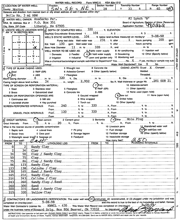
Specific Water Well Detail |
|
|
| Location Info | |||
| Owner: Anadarko Petroleum Corp. | Status: Constructed | ||
| Location: T33S, R40W, Sec. 28, SW SE NE | County: Morton | ||
| Directions: from Rolla, 3 mi N-NW | |||
| Latitude: 37.149883 | Longitude: -101.6675362 | Datum NAD 27 | |
| Latitude: 37.1499077 | Longitude: -101.6679761 | Datum NAD 83 | |
| Longitude and latitude calculated by Survey from township-range-section-quarter calls. Only good to within the quarter call accuracy. | |||
| View well on interactive map | |||
| General Info | ||
| Well Depth: 320 ft. | Elevation: ft. | |
| Static Water Level: 104 ft. | Est. Yield: 100 gpm. | |
| Comp. Date: 08-Sep-1998 | Well Use: Oil Field Water Supply | |
| DWR Applic. #: 980262 | Other ID: Lynch B-2 | |
| Links | |
| No Wizard information available. | |
| View info from WIMAS Water Right Data base... | |
| Driller Info | ||
| Driller: Howard Drilling Company AG, LLC | License #: 430 | |
| Scanned Form | View scan |
|
Chemical Sample Submitted?:
Water Well disinfected?: | ||
| Casing Info | ||
| Casing Type:
Casing Joints: |
Diam: in. to ft | |
| Casing height above land surface: in
Casing Weight: lbs/ft Wall thickness or gauge no.: | ||
| Screen and Perforation Info | ||
| Screen Type: | Screen Openings: | |
| Screen-perforated intervals | From: ft to ft | |
| Gravel pack intervals | From: ft to ft | |
| Grout Info | ||
| Grout used: | From: to ft | |
| Source of Possible Contamination | ||
| Source: | ||
| Direction from well: | Distance: ft | |
| Lithologic Log
(Log data entered by KGS.) | ||
| From: 0 ft. to 2 ft. | sandy clay | |
| From: 2 ft. to 34 ft. | clay | |
| From: 34 ft. to 50 ft. | clay / sandy clay | |
| From: 50 ft. to 75 ft. | clay | |
| From: 75 ft. to 86 ft. | clay / sandy clay | |
| From: 86 ft. to 123 ft. | sandy clay | |
| From: 123 ft. to 138 ft. | caliche / clay | |
| From: 138 ft. to 165 ft. | sand / sandy clay | |
| From: 165 ft. to 214 ft. | sandy clay | |
| From: 214 ft. to 243 ft. | caliche / clay | |
| From: 243 ft. to 260 ft. | sandy clay / sand | |
| From: 260 ft. to 300 ft. | sand | |
| From: 300 ft. to 315 ft. | sand / sandy clay | |
| From: 315 ft. to 320 ft. | yellow clay | |