|
|
|
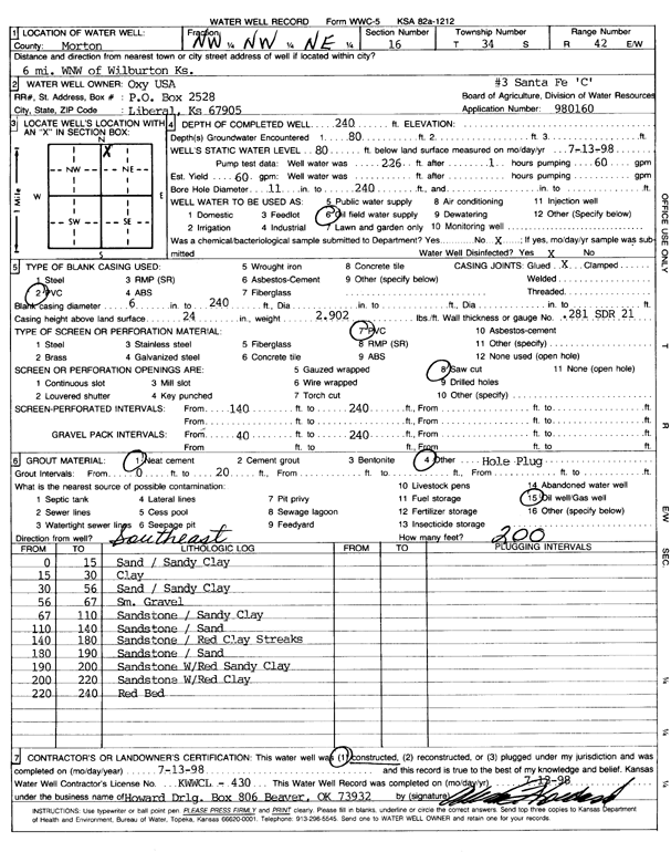
Specific Water Well Detail |
|
|
| Location Info | |||
| Owner: Oxy USA, Inc. | Status: Constructed | ||
| Location: T34S, R42W, Sec. 16, NW NW NE | County: Morton | ||
| Directions: From Wilburton, 6 miles West-Northwest | |||
| Latitude: 37.0967083 | Longitude: -101.889141 | Datum NAD 27 | |
| Latitude: 37.0967315 | Longitude: -101.8895861 | Datum NAD 83 | |
| Longitude and latitude calculated by Survey from township-range-section-quarter calls. Only good to within the quarter call accuracy. | |||
| View well on interactive map | |||
| General Info | ||
| Well Depth: 240 ft. | Elevation: ft. | |
| Static Water Level: 80 ft. | Est. Yield: 60 gpm. | |
| Comp. Date: 13-Jul-1998 | Well Use: Oil Field Water Supply | |
| DWR Applic. #: 980160 | Other ID: Santa Fe C 3 | |
| Links | |
| No Wizard information available. | |
| View info from WIMAS Water Right Data base... | |
| Driller Info | ||
| Driller: Howard Drilling Company AG, LLC | License #: 430 | |
| Scanned Form | View scan |
|
Chemical Sample Submitted?:
Water Well disinfected?: | ||
| Casing Info | ||
| Casing Type:
Casing Joints: |
Diam: in. to ft | |
| Casing height above land surface: in
Casing Weight: lbs/ft Wall thickness or gauge no.: | ||
| Screen and Perforation Info | ||
| Screen Type: | Screen Openings: | |
| Screen-perforated intervals | From: ft to ft | |
| Gravel pack intervals | From: ft to ft | |
| Grout Info | ||
| Grout used: | From: to ft | |
| Source of Possible Contamination | ||
| Source: | ||
| Direction from well: | Distance: ft | |
| Lithologic Log
(Log data entered by KGS.) | ||
| From: 0 ft. to 15 ft. | sand / sandy clay | |
| From: 15 ft. to 30 ft. | clay | |
| From: 30 ft. to 56 ft. | sand / sandy clay | |
| From: 56 ft. to 67 ft. | small gravel | |
| From: 67 ft. to 110 ft. | sandstone / sandy clay | |
| From: 110 ft. to 140 ft. | sandstone / sand | |
| From: 140 ft. to 180 ft. | sandstone / red clay streaks | |
| From: 180 ft. to 190 ft. | sandstone / sand | |
| From: 190 ft. to 200 ft. | sandstone with red sandy clay | |
| From: 200 ft. to 220 ft. | sandstone with red clay | |
| From: 220 ft. to 240 ft. | red bed | |