|
|
|
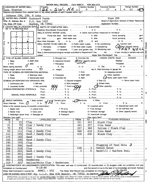
Specific Water Well Detail |
|
|
| Location Info | |||
| Owner: Seaboard Farms Co. | Status: Constructed | ||
| Location: T27S, R43W, Sec. 9, SE SW NE | County: Stanton | ||
| Directions: from Johnson, 10 mi N, 15 mi W, and S into site | |||
| Latitude: 37.717632 | Longitude: -102.0217306 | Datum NAD 27 | |
| Latitude: 37.7176446 | Longitude: -102.0221883 | Datum NAD 83 | |
| Longitude and latitude calculated by Survey from township-range-section-quarter calls. Only good to within the quarter call accuracy. | |||
| View well on interactive map | |||
| General Info | ||
| Well Depth: 430 ft. | Elevation: ft. | |
| Static Water Level: ft. | Est. Yield: gpm. | |
| Comp. Date: 18-Sep-1998 | Well Use: Test hole/well | |
| DWR Applic. #: | Other ID: Test Hole 3 | |
| Driller Info | ||
| Driller: H.D.C. AG, LLC | License #: 652 | |
| Scanned Form | View scan |
|
Chemical Sample Submitted?:
Water Well disinfected?: | ||
| Casing Info | ||
| Casing Type:
Casing Joints: |
Diam: in. to ft | |
| Casing height above land surface: in
Casing Weight: lbs/ft Wall thickness or gauge no.: | ||
| Screen and Perforation Info | ||
| Screen Type: | Screen Openings: | |
| Screen-perforated intervals | From: ft to ft | |
| Gravel pack intervals | From: ft to ft | |
| Grout Info | ||
| Grout used: | From: to ft | |
| Source of Possible Contamination | ||
| Source: | ||
| Direction from well: | Distance: ft | |
| Lithologic Log
(Log data entered by KGS.) | ||
| From: 0 ft. to 21 ft. | clay | |
| From: 21 ft. to 70 ft. | clay and sandy clay | |
| From: 70 ft. to 83 ft. | clay | |
| From: 83 ft. to 111 ft. | clay and sandy clay | |
| From: 111 ft. to 145 ft. | sand and sandy clay | |
| From: 145 ft. to 160 ft. | sand | |
| From: 160 ft. to 190 ft. | sand and sandy clay | |
| From: 190 ft. to 193 ft. | clay | |
| From: 193 ft. to 206 ft. | sand | |
| From: 206 ft. to 218 ft. | clay | |
| From: 218 ft. to 240 ft. | sand and sandy clay | |
| From: 240 ft. to 281 ft. | sand | |
| From: 281 ft. to 302 ft. | sand and sandy clay | |
| From: 302 ft. to 310 ft. | sandstone | |
| From: 310 ft. to 321 ft. | yellow and white clay with sandstone | |
| From: 321 ft. to 342 ft. | black clay | |
| From: 342 ft. to 357 ft. | fine sand | |
| From: 357 ft. to 368 ft. | yellow and black clay | |
| From: 368 ft. to 418 ft. | fine sand | |
| From: 418 ft. to 430 ft. | black clay | |