|
|
|
Specific Water Well Detail |
|
|
| Location Info | |||
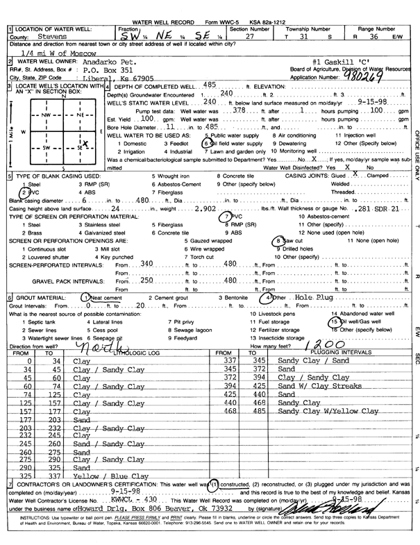
| Owner: Anadarko Petroleum Corp. | Status: Constructed | ||
| Location: T31S, R36W, Sec. 27, SW NE SE | County: Stevens | ||
| Directions: from Moscow, 0.25 mi W | |||
| Latitude: 37.3195018 | Longitude: -101.2155482 | Datum NAD 27 | |
| Latitude: 37.3195256 | Longitude: -101.2159865 | Datum NAD 83 | |
| Longitude and latitude calculated by Survey from township-range-section-quarter calls. Only good to within the quarter call accuracy. | |||
| View well on interactive map | |||
| General Info | ||
| Well Depth: 485 ft. | Elevation: ft. | |
| Static Water Level: 240 ft. | Est. Yield: 100 gpm. | |
| Comp. Date: 15-Sep-1998 | Well Use: Oil Field Water Supply | |
| DWR Applic. #: 980269 | Other ID: Gaskill C-1 | |
| Links | |
| No Wizard information available. | |
| View info from WIMAS Water Right Data base... | |
| Driller Info | ||
| Driller: Howard Drilling Company AG, LLC | License #: 430 | |
| Scanned Form | View scan |
|
Chemical Sample Submitted?:
Water Well disinfected?: | ||
| Casing Info | ||
| Casing Type:
Casing Joints: |
Diam: in. to ft | |
| Casing height above land surface: in
Casing Weight: lbs/ft Wall thickness or gauge no.: | ||
| Screen and Perforation Info | ||
| Screen Type: | Screen Openings: | |
| Screen-perforated intervals | From: ft to ft | |
| Gravel pack intervals | From: ft to ft | |
| Grout Info | ||
| Grout used: | From: to ft | |
| Source of Possible Contamination | ||
| Source: | ||
| Direction from well: | Distance: ft | |
| Lithologic Log
(Log data entered by KGS.) | ||
| From: 0 ft. to 34 ft. | clay | |
| From: 34 ft. to 45 ft. | clay / sandy clay | |
| From: 45 ft. to 60 ft. | clay | |
| From: 60 ft. to 74 ft. | clay / sandy clay | |
| From: 74 ft. to 125 ft. | clay | |
| From: 125 ft. to 157 ft. | clay / sandy clay | |
| From: 157 ft. to 177 ft. | clay | |
| From: 177 ft. to 203 ft. | sand | |
| From: 203 ft. to 232 ft. | clay / sandy clay | |
| From: 232 ft. to 245 ft. | clay | |
| From: 245 ft. to 260 ft. | sand / sandy clay | |
| From: 260 ft. to 275 ft. | sand | |
| From: 275 ft. to 290 ft. | clay / sandy clay | |
| From: 290 ft. to 325 ft. | sand | |
| From: 325 ft. to 337 ft. | yellow / blue clay | |
| From: 337 ft. to 345 ft. | sandy clay / sand | |
| From: 345 ft. to 372 ft. | sand | |
| From: 372 ft. to 394 ft. | clay / sandy clay | |
| From: 394 ft. to 425 ft. | sand with clay streaks | |
| From: 425 ft. to 440 ft. | sand | |
| From: 440 ft. to 468 ft. | sandy clay | |
| From: 468 ft. to 485 ft. | sandy clay with yellow clay | |