|
|
|
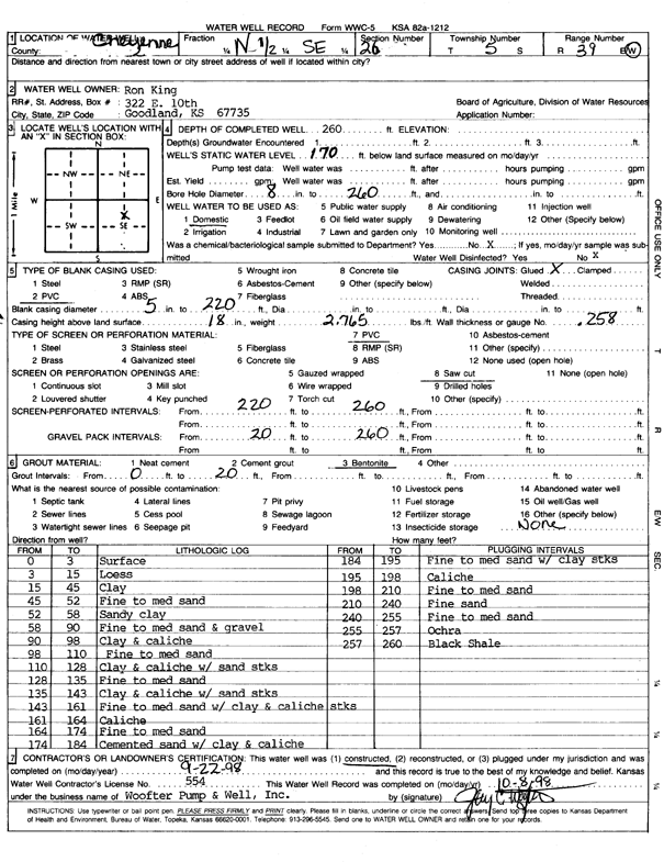
Specific Water Well Detail |
|
|
| Location Info | |||
| Owner: King, Ron | Status: Constructed | ||
| Location: T5S, R39W, Sec. 26, N SE | County: Cheyenne | ||
| Directions: | |||
| Latitude: 39.5865728 | Longitude: -101.6614637 | Datum NAD 27 | |
| Latitude: 39.5865689 | Longitude: -101.6619122 | Datum NAD 83 | |
| Longitude and latitude calculated by Survey from township-range-section-quarter calls. Only good to within the quarter call accuracy. | |||
| View well on interactive map | |||
| General Info | ||
| Well Depth: 260 ft. | Elevation: ft. | |
| Static Water Level: 170 ft. | Est. Yield: gpm. | |
| Comp. Date: 22-Sep-1998 | Well Use: Domestic | |
| DWR Applic. #: | Other ID: | |
| Driller Info | ||
| Driller: Woofter Pump & Well, Inc. | License #: 554 | |
| Scanned Form | View scan |
|
Chemical Sample Submitted?:
Water Well disinfected?: | ||
| Casing Info | ||
| Casing Type:
Casing Joints: |
Diam: in. to ft | |
| Casing height above land surface: in
Casing Weight: lbs/ft Wall thickness or gauge no.: | ||
| Screen and Perforation Info | ||
| Screen Type: | Screen Openings: | |
| Screen-perforated intervals | From: ft to ft | |
| Gravel pack intervals | From: ft to ft | |
| Grout Info | ||
| Grout used: | From: to ft | |
| Source of Possible Contamination | ||
| Source: | ||
| Direction from well: | Distance: ft | |
| Lithologic Log
(Log data entered by KGS.) | ||
| From: 0 ft. to 3 ft. | Surface | |
| From: 3 ft. to 15 ft. | Loess | |
| From: 15 ft. to 45 ft. | Clay | |
| From: 45 ft. to 52 ft. | Fine to medium sand | |
| From: 52 ft. to 58 ft. | Sandy clay | |
| From: 58 ft. to 90 ft. | Fine to medium sand and gravel | |
| From: 90 ft. to 98 ft. | Clay and caliche | |
| From: 98 ft. to 110 ft. | Fine to medium sand | |
| From: 110 ft. to 128 ft. | Clay and caliche with sand streaks | |
| From: 128 ft. to 135 ft. | Fine to medium sand | |
| From: 135 ft. to 143 ft. | Clay and caliche with sand streaks | |
| From: 143 ft. to 161 ft. | Fine to medium sand with clay and caliche streaks | |
| From: 161 ft. to 164 ft. | Caliche | |
| From: 164 ft. to 174 ft. | Fine to medium sand | |
| From: 174 ft. to 184 ft. | Cemented sand with clay and caliche | |
| From: 184 ft. to 195 ft. | Fine to medium sand with clay streaks | |
| From: 195 ft. to 198 ft. | Caliche | |
| From: 198 ft. to 210 ft. | Fine to medium sand | |
| From: 210 ft. to 240 ft. | Fine sand | |
| From: 240 ft. to 255 ft. | Fine to medium sand | |
| From: 255 ft. to 257 ft. | Ochre | |
| From: 257 ft. to 260 ft. | Black shale | |