|
|
|
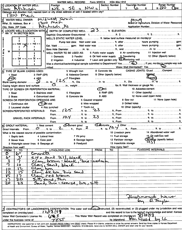
Specific Water Well Detail |
|
|
| Location Info | |||
| Owner: Midwest Grain | Status: Constructed | ||
| Location: T6S, R20E, Sec. 1, NE SE NW | County: Atchison | ||
| Directions: 1300 Main, Atchison | |||
| Latitude: 39.5606213 | Longitude: -95.1340485 | Datum NAD 27 | |
| Latitude: 39.5606179 | Longitude: -95.1342954 | Datum NAD 83 | |
| Longitude and latitude calculated by Survey from township-range-section-quarter calls. Only good to within the quarter call accuracy. | |||
| View well on interactive map | |||
| General Info | ||
| Well Depth: 23 ft. | Elevation: ft. | |
| Static Water Level: ft. | Est. Yield: gpm. | |
| Comp. Date: 20-Aug-1997 | Well Use: Monitoring well/observation/piezometer | |
| DWR Applic. #: | Other ID: MW 9 | |
| Driller Info | ||
| Driller: Defenbaugh Industries, Inc. (T.E.S.T.) | License #: 483 | |
| Scanned Form | View scan |
|
Chemical Sample Submitted?:
Water Well disinfected?: | ||
| Casing Info | ||
| Casing Type:
Casing Joints: |
Diam: in. to ft | |
| Casing height above land surface: in
Casing Weight: lbs/ft Wall thickness or gauge no.: | ||
| Screen and Perforation Info | ||
| Screen Type: | Screen Openings: | |
| Screen-perforated intervals | From: ft to ft | |
| Gravel pack intervals | From: ft to ft | |
| Grout Info | ||
| Grout used: | From: to ft | |
| Source of Possible Contamination | ||
| Source: | ||
| Direction from well: | Distance: ft | |
| Lithologic Log
(Log data entered by KGS.) | ||
| From: 0 ft. to .5 ft. | Concrete | |
| From: .5 ft. to 3 ft. | Silt and sand fill, black | |
| From: 3 ft. to 7 ft. | Clay, brown-black, fine-medium | |
| From: 7 ft. to 10 ft. | Clay, sand, black | |
| From: 10 ft. to 12 ft. | Clay, brown | |
| From: 12 ft. to 15 ft. | Clay, dark brown, fine sand | |
| From: 15 ft. to 17 ft. | Clay, red brown | |
| From: 17 ft. to 20 ft. | Silt, sand, tan | |
| From: 20 ft. to 23 ft. | Sand, fine-coarse, brown, silt | |