|
|
|
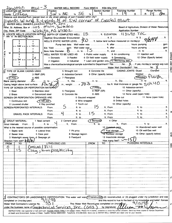
Specific Water Well Detail |
|
|
| Location Info | |||
| Owner: Coastal Mart | Status: Constructed | ||
| Location: T19S, R14E, Sec. 4, SW NE SE | County: Coffey | ||
| Directions: from SW corner of Coastal Mart, 33 feet W and 10.2 feet N (id 26W090) | |||
| Latitude: 38.4238334 | Longitude: -95.8610566 | Datum NAD 27 | |
| Latitude: 38.4238482 | Longitude: -95.8613231 | Datum NAD 83 | |
| Longitude and latitude calculated by Survey from township-range-section-quarter calls. Only good to within the quarter call accuracy. | |||
| View well on interactive map | |||
| General Info | ||
| Well Depth: 15 ft. | Elevation: 1131.9 ft. | |
| Static Water Level: 9 ft. | Est. Yield: gpm. | |
| Comp. Date: 01-Sep-1998 | Well Use: Monitoring well/observation/piezometer | |
| DWR Applic. #: | Other ID: MW 3 | |
| Driller Info | ||
| Driller: Geotechnical Services, Inc. | License #: 531 | |
| Scanned Form | View scan |
|
Chemical Sample Submitted?:
Water Well disinfected?: | ||
| Casing Info | ||
| Casing Type:
Casing Joints: |
Diam: in. to ft | |
| Casing height above land surface: in
Casing Weight: lbs/ft Wall thickness or gauge no.: | ||
| Screen and Perforation Info | ||
| Screen Type: | Screen Openings: | |
| Screen-perforated intervals | From: ft to ft | |
| Gravel pack intervals | From: ft to ft | |
| Grout Info | ||
| Grout used: | From: to ft | |
| Source of Possible Contamination | ||
| Source: | ||
| Direction from well: | Distance: ft | |
| Lithologic Log
(Log data entered by KGS.) | ||
| From: 0 ft. to 1 ft. | gravel and fill | |
| From: 1 ft. to 15 ft. | clay, high-medium plasticity | |