|
|
|
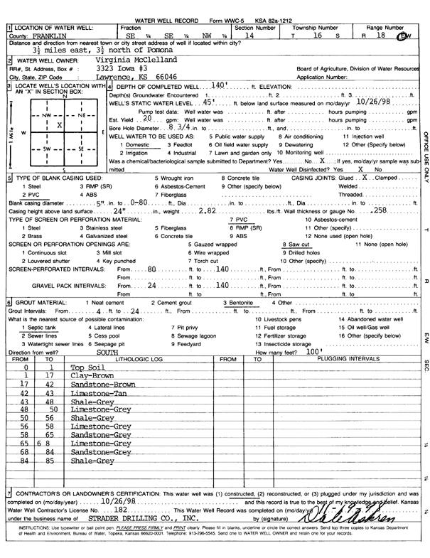
Specific Water Well Detail |
|
|
| Location Info | |||
| Owner: McClelland, Virginia | Status: Constructed | ||
| Location: T16S, R18E, Sec. 14, SE SE NW | County: Franklin | ||
| Directions: from Pomona, 3.5 mi E and 3.5 mi N | |||
| Latitude: 38.6602988 | Longitude: -95.3891805 | Datum NAD 27 | |
| Latitude: 38.660308 | Longitude: -95.3894354 | Datum NAD 83 | |
| Longitude and latitude calculated by Survey from township-range-section-quarter calls. Only good to within the quarter call accuracy. | |||
| View well on interactive map | |||
| General Info | ||
| Well Depth: 140 ft. | Elevation: ft. | |
| Static Water Level: 45 ft. | Est. Yield: 20 gpm. | |
| Comp. Date: 26-Oct-1998 | Well Use: Domestic | |
| DWR Applic. #: | Other ID: | |
| Driller Info | ||
| Driller: Strader Drilling Co., Inc. | License #: 182 | |
| Scanned Form | View scan |
|
Chemical Sample Submitted?:
Water Well disinfected?: | ||
| Casing Info | ||
| Casing Type:
Casing Joints: |
Diam: in. to ft | |
| Casing height above land surface: in
Casing Weight: lbs/ft Wall thickness or gauge no.: | ||
| Screen and Perforation Info | ||
| Screen Type: | Screen Openings: | |
| Screen-perforated intervals | From: ft to ft | |
| Gravel pack intervals | From: ft to ft | |
| Grout Info | ||
| Grout used: | From: to ft | |
| Source of Possible Contamination | ||
| Source: | ||
| Direction from well: | Distance: ft | |
| Lithologic Log
(Log data entered by KGS.) | ||
| From: 0 ft. to 1 ft. | Topsoil | |
| From: 1 ft. to 17 ft. | Clay, brown | |
| From: 17 ft. to 42 ft. | Sandstone, brown | |
| From: 42 ft. to 43 ft. | Limestone, tan | |
| From: 43 ft. to 48 ft. | Shale, gray | |
| From: 48 ft. to 50 ft. | Limestone, gray | |
| From: 50 ft. to 56 ft. | Shale, gray | |
| From: 56 ft. to 58 ft. | Limestone, gray | |
| From: 58 ft. to 65 ft. | Sandstone, gray | |
| From: 65 ft. to 68 ft. | Limestone, gray | |
| From: 68 ft. to 84 ft. | Sandstone, gray | |
| From: 84 ft. to 85 ft. | Shale, gray | |