|
|
|
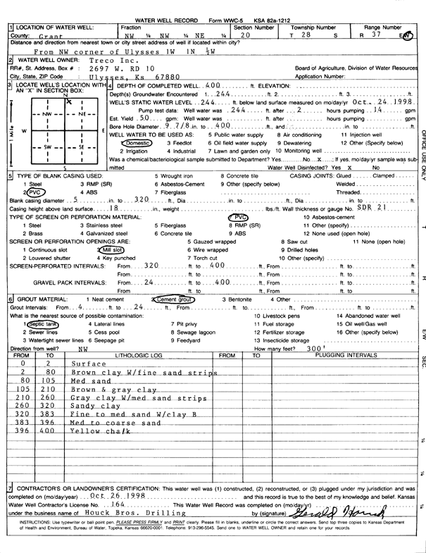
Specific Water Well Detail |
|
|
| Location Info | |||
| Owner: Treco Inc. | Status: Constructed | ||
| Location: T28S, R37W, Sec. 20, NW NW NE | County: Grant | ||
| Directions: from NW corner of Ulysses: 1 mi W, 1 mi N, and 0.5 mi W | |||
| Latitude: 37.6046471 | Longitude: -101.3891572 | Datum NAD 27 | |
| Latitude: 37.6046669 | Longitude: -101.3896048 | Datum NAD 83 | |
| Longitude and latitude calculated by Survey from township-range-section-quarter calls. Only good to within the quarter call accuracy. | |||
| View well on interactive map | |||
| General Info | ||
| Well Depth: 400 ft. | Elevation: ft. | |
| Static Water Level: 244 ft. | Est. Yield: 50 gpm. | |
| Comp. Date: 26-Oct-1998 | Well Use: Domestic | |
| DWR Applic. #: | Other ID: | |
| Driller Info | ||
| Driller: Houck Brothers Drilling, Inc. | License #: 164 | |
| Scanned Form | View scan |
|
Chemical Sample Submitted?:
Water Well disinfected?: | ||
| Casing Info | ||
| Casing Type:
Casing Joints: |
Diam: in. to ft | |
| Casing height above land surface: in
Casing Weight: lbs/ft Wall thickness or gauge no.: | ||
| Screen and Perforation Info | ||
| Screen Type: | Screen Openings: | |
| Screen-perforated intervals | From: ft to ft | |
| Gravel pack intervals | From: ft to ft | |
| Grout Info | ||
| Grout used: | From: to ft | |
| Source of Possible Contamination | ||
| Source: | ||
| Direction from well: | Distance: ft | |
| Lithologic Log
(Log data entered by KGS.) | ||
| From: 0 ft. to 2 ft. | Surface | |
| From: 2 ft. to 80 ft. | Brown clay W/fine sand strips | |
| From: 80 ft. to 105 ft. | Med sand | |
| From: 105 ft. to 210 ft. | Brown and gray clay | |
| From: 210 ft. to 260 ft. | Gray clay with medium sand strips | |
| From: 260 ft. to 320 ft. | Sandy clay | |
| From: 320 ft. to 383 ft. | Fine to medium sand with clay breakers | |
| From: 383 ft. to 396 ft. | Med to coarse sand | |
| From: 396 ft. to 400 ft. | Yellow chalk | |