|
|
|
Specific Water Well Detail |
|
|
| Location Info | |||
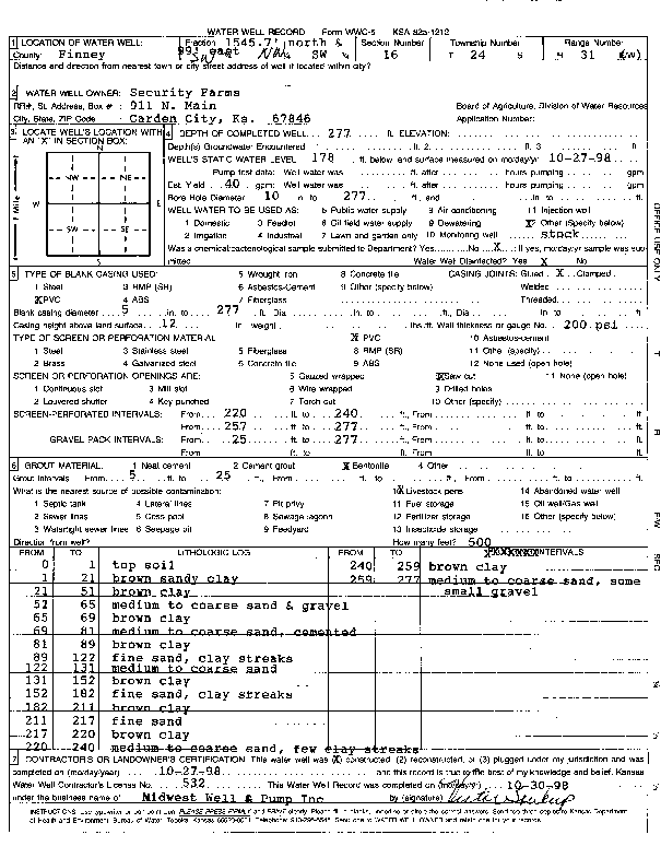
| Owner: Security Farms | Status: Constructed | ||
| Location: T24S, R31W, Sec. 16, SW NW SW | County: Finney | ||
| Directions: from the SW sec corner, 1545.7' N, 99' E | |||
| Latitude: 37.9641869 | Longitude: -100.7361705 | Datum NAD 27 | |
| Latitude: 37.9642089 | Longitude: -100.7366048 | Datum NAD 83 | |
| Longitude and latitude calculated by Survey from township-range-section-quarter calls. Only good to within the quarter call accuracy. | |||
| View well on interactive map | |||
| General Info | ||
| Well Depth: 277 ft. | Elevation: ft. | |
| Static Water Level: 178 ft. | Est. Yield: gpm. | |
| Comp. Date: 27-Oct-1998 | Well Use: Domestic, Livestock | |
| DWR Applic. #: | Other ID: | |
| Driller Info | ||
| Driller: Midwest Well & Pump, Inc. | License #: 532 | |
| Scanned Form | View scan |
|
Chemical Sample Submitted?:
Water Well disinfected?: | ||
| Casing Info | ||
| Casing Type:
Casing Joints: |
Diam: in. to ft | |
| Casing height above land surface: in
Casing Weight: lbs/ft Wall thickness or gauge no.: | ||
| Screen and Perforation Info | ||
| Screen Type: | Screen Openings: | |
| Screen-perforated intervals | From: ft to ft | |
| Gravel pack intervals | From: ft to ft | |
| Grout Info | ||
| Grout used: | From: to ft | |
| Source of Possible Contamination | ||
| Source: | ||
| Direction from well: | Distance: ft | |
| Lithologic Log
(Log data entered by KGS.) | ||
| From: 0 ft. to 1 ft. | top soil | |
| From: 1 ft. to 21 ft. | brown sandy clay | |
| From: 21 ft. to 51 ft. | brown clay | |
| From: 51 ft. to 65 ft. | medium to coarse sand and gravel | |
| From: 65 ft. to 69 ft. | brown clay | |
| From: 69 ft. to 81 ft. | medium to coarse sand, cemented | |
| From: 81 ft. to 89 ft. | brown clay | |
| From: 89 ft. to 122 ft. | fine sand, clay streaks | |
| From: 122 ft. to 131 ft. | medium to coarse sand | |
| From: 131 ft. to 152 ft. | brown clay | |
| From: 152 ft. to 182 ft. | fine sand, clay streaks | |
| From: 182 ft. to 211 ft. | brown clay | |
| From: 211 ft. to 217 ft. | fine sand | |
| From: 217 ft. to 220 ft. | brown clay | |
| From: 220 ft. to 240 ft. | medium to coarse sand, few clay streaks | |
| From: 240 ft. to 259 ft. | brown clay | |
| From: 259 ft. to 277 ft. | medium to coarse sand, some small gravel | |