|
|
|
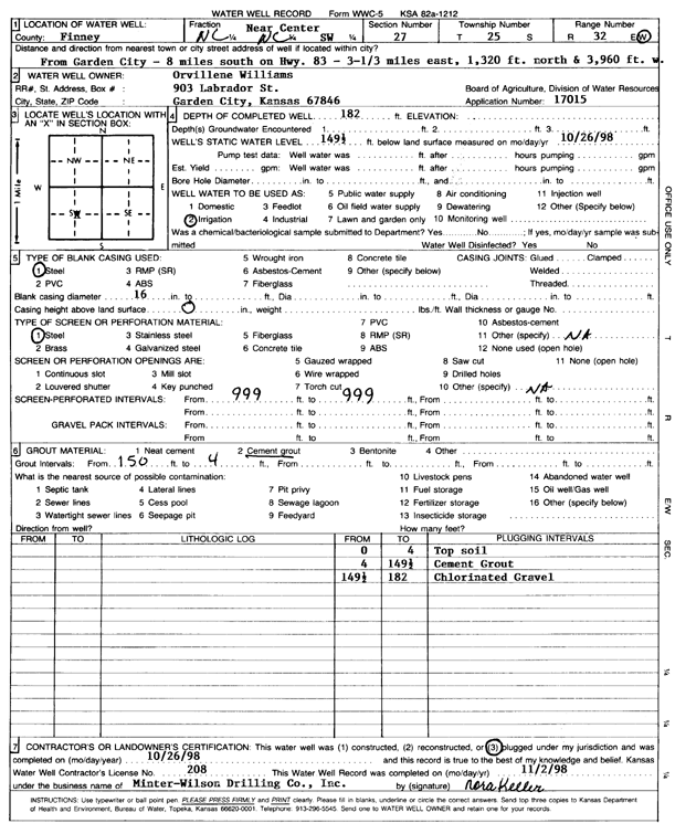
Specific Water Well Detail |
|
|
| Location Info | |||
| Owner: Williams, Orvillene | Status: Plugged | ||
| Location: T25S, R32W, Sec. 27, C SW | County: Finney | ||
| Directions: from Garden City: 8 mi S on Hwy 83, 3.3 mi E, 1320 feet N, 3960 feet W | |||
| Latitude: 37.8476189 | Longitude: -100.8240843 | Datum NAD 27 | |
| Latitude: 37.8476423 | Longitude: -100.8245233 | Datum NAD 83 | |
| Longitude and latitude calculated by Survey from township-range-section-quarter calls. Only good to within the quarter call accuracy. | |||
| View well on interactive map | |||
| General Info | ||
| Well Depth: 182 ft. | Elevation: ft. | |
| Static Water Level: 149.5 ft. | Est. Yield: gpm. | |
| Comp. Date: 26-Oct-1998 | Well Use: Irrigation | |
| DWR Applic. #: 17015 | Other ID: | |
| Links | |
| View info from Wizard Water Level Data base... | |
| View info from WIMAS Water Right Data base... | |
| Driller Info | ||
| Driller: Minter-Wilson Drilling Co Inc | License #: 208 | |
| Scanned Form | View scan |
| Casing Info | ||
|
Casing Type:
Diam: in. Casing height above land surface: in | ||
| Grout Info | ||
| Grout used: | From: to ft | |
| Source of Possible Contamination | ||
| Source: | ||
| Direction from well: | Distance: ft | |