|
|
|
Specific Water Well Detail |
|
|
| Location Info | |||
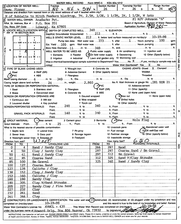
| Owner: Anadarko Petroleum Corp. | Status: Constructed | ||
| Location: T26S, R34W, Sec. 26, NE NE SW | County: Finney | ||
| Directions: N of Sublette to Hitch Feeders blacktop, 7 mi W, 2.5 mi N, 0.5 mi E, 1.5 mi N, 1 mi W, 1.5 mi N, W into site | |||
| Latitude: 37.7577228 | Longitude: -101.0082865 | Datum NAD 27 | |
| Latitude: 37.7577463 | Longitude: -101.0087334 | Datum NAD 83 | |
| Longitude and latitude calculated by Survey from township-range-section-quarter calls. Only good to within the quarter call accuracy. | |||
| View well on interactive map | |||
| General Info | ||
| Well Depth: 340 ft. | Elevation: ft. | |
| Static Water Level: 212 ft. | Est. Yield: 100 gpm. | |
| Comp. Date: 19-Oct-1998 | Well Use: Oil Field Water Supply | |
| DWR Applic. #: 980285 | Other ID: HJV Johnson A-1 | |
| Links | |
| No Wizard information available. | |
| View info from WIMAS Water Right Data base... | |
| Driller Info | ||
| Driller: Howard Drilling Company AG, LLC | License #: 430 | |
| Scanned Form | View scan |
|
Chemical Sample Submitted?:
Water Well disinfected?: | ||
| Casing Info | ||
| Casing Type:
Casing Joints: |
Diam: in. to ft | |
| Casing height above land surface: in
Casing Weight: lbs/ft Wall thickness or gauge no.: | ||
| Screen and Perforation Info | ||
| Screen Type: | Screen Openings: | |
| Screen-perforated intervals | From: ft to ft | |
| Gravel pack intervals | From: ft to ft | |
| Grout Info | ||
| Grout used: | From: to ft | |
| Source of Possible Contamination | ||
| Source: | ||
| Direction from well: | Distance: ft | |
| Lithologic Log
(Log data entered by KGS.) | ||
| From: 0 ft. to 4 ft. | sand / sandy clay | |
| From: 4 ft. to 50 ft. | clay / sandy clay | |
| From: 50 ft. to 61 ft. | sand / sandy clay | |
| From: 61 ft. to 85 ft. | coarse sand | |
| From: 85 ft. to 100 ft. | sm gravel | |
| From: 100 ft. to 127 ft. | coarse sand | |
| From: 127 ft. to 138 ft. | caliche / clay | |
| From: 138 ft. to 152 ft. | clay / sandy clay | |
| From: 152 ft. to 160 ft. | caliche / clay | |
| From: 160 ft. to 180 ft. | sandy clay | |
| From: 180 ft. to 205 ft. | clay with sand streaks | |
| From: 205 ft. to 227 ft. | sandy clay / fine sand | |
| From: 227 ft. to 232 ft. | clay | |
| From: 232 ft. to 261 ft. | sand | |
| From: 261 ft. to 266 ft. | clay | |
| From: 266 ft. to 287 ft. | sand | |
| From: 287 ft. to 297 ft. | coarse sand / sm gravel | |
| From: 297 ft. to 312 ft. | sm gravel | |
| From: 312 ft. to 325 ft. | sand with clay streaks | |
| From: 325 ft. to 340 ft. | sand / sandy clay | |