|
|
|
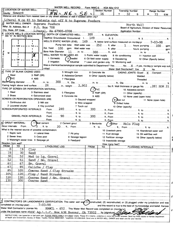
Specific Water Well Detail |
|
|
| Location Info | |||
| Owner: Supreme Feeders | Status: Constructed | ||
| Location: T32S, R33W, Sec. 16, NW NE SE | County: Seward | ||
| Directions: Liveral N on 83 to Satanta cut off, N to supreme feeders | |||
| Latitude: 37.2636399 | Longitude: -100.907784 | Datum NAD 27 | |
| Latitude: 37.2636625 | Longitude: -100.908224 | Datum NAD 83 | |
| Longitude and latitude calculated by Survey from township-range-section-quarter calls. Only good to within the quarter call accuracy. | |||
| View well on interactive map | |||
| General Info | ||
| Well Depth: 300 ft. | Elevation: ft. | |
| Static Water Level: 149 ft. | Est. Yield: gpm. | |
| Comp. Date: 03-Jul-1998 | Well Use: Feedlot | |
| DWR Applic. #: | Other ID: North Well | |
| Links | |
| No Wizard information available. | |
| View info from WIMAS Water Right Data base... | |
| Driller Info | ||
| Driller: H.D.C. AG, LLC | License #: 652 | |
| Scanned Form | View scan |
|
Chemical Sample Submitted?:
Water Well disinfected?: | ||
| Casing Info | ||
| Casing Type:
Casing Joints: |
Diam: in. to ft | |
| Casing height above land surface: in
Casing Weight: lbs/ft Wall thickness or gauge no.: | ||
| Screen and Perforation Info | ||
| Screen Type: | Screen Openings: | |
| Screen-perforated intervals | From: ft to ft | |
| Gravel pack intervals | From: ft to ft | |
| Grout Info | ||
| Grout used: | From: to ft | |
| Source of Possible Contamination | ||
| Source: | ||
| Direction from well: | Distance: ft | |
| Lithologic Log
(Log data entered by KGS.) | ||
| From: 0 ft. to 19 ft. | clay | |
| From: 19 ft. to 30 ft. | sand | |
| From: 30 ft. to 52 ft. | med to lg gravel | |
| From: 52 ft. to 61 ft. | sand/sm gravel | |
| From: 61 ft. to 67 ft. | sm gravel | |
| From: 67 ft. to 85 ft. | caliche/clay | |
| From: 85 ft. to 105 ft. | coarse sand/clay streaks | |
| From: 105 ft. to 120 ft. | clay/sand streaks | |
| From: 120 ft. to 130 ft. | coarse sand/sm gravel | |
| From: 130 ft. to 300 ft. | coarse sand | |