|
|
|
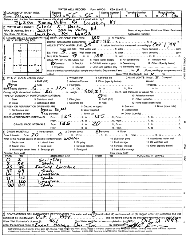
Specific Water Well Detail |
|
|
| Location Info | |||
| Owner: Beck, Calvin E. | Status: Constructed | ||
| Location: T16S, R24E, Sec. 14, SW SE SE | County: Miami | ||
| Directions: 26280 Spring Valley Road, Louisburg | |||
| Latitude: 38.651257 | Longitude: -94.7162655 | Datum NAD 27 | |
| Latitude: 38.6512685 | Longitude: -94.716501 | Datum NAD 83 | |
| Longitude and latitude calculated by Survey from township-range-section-quarter calls. Only good to within the quarter call accuracy. | |||
| View well on interactive map | |||
| General Info | ||
| Well Depth: 135 ft. | Elevation: ft. | |
| Static Water Level: 35 ft. | Est. Yield: 5 gpm. | |
| Comp. Date: 01-Oct-1998 | Well Use: Domestic | |
| DWR Applic. #: | Other ID: | |
| Driller Info | ||
| Driller: Evans Energy Development, Inc. | License #: 561 | |
| Scanned Form | View scan |
|
Chemical Sample Submitted?:
Water Well disinfected?: | ||
| Casing Info | ||
| Casing Type:
Casing Joints: |
Diam: in. to ft | |
| Casing height above land surface: in
Casing Weight: lbs/ft Wall thickness or gauge no.: | ||
| Screen and Perforation Info | ||
| Screen Type: | Screen Openings: | |
| Screen-perforated intervals | From: ft to ft | |
| Gravel pack intervals | From: ft to ft | |
| Grout Info | ||
| Grout used: | From: to ft | |
| Source of Possible Contamination | ||
| Source: | ||
| Direction from well: | Distance: ft | |
| Lithologic Log
(Log data entered by KGS.) | ||
| From: 0 ft. to 2 ft. | soil and clay | |
| From: 2 ft. to 35 ft. | shale | |
| From: 35 ft. to 48 ft. | fractured limestone | |
| From: 48 ft. to 64 ft. | shale | |
| From: 64 ft. to 71 ft. | limestone | |
| From: 71 ft. to 112 ft. | shale | |
| From: 112 ft. to 120 ft. | limestone | |
| From: 120 ft. to 135 ft. | shale | |