|
|
|
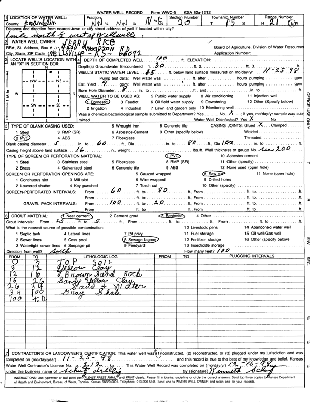
Specific Water Well Detail |
|
|
| Location Info | |||
| Owner: Rice, Jerry | Status: Constructed | ||
| Location: T15S, R21E, Sec. 20, NE NW NW | County: Franklin | ||
| Directions: from Wellsville, 1 mi N and 0.5 mi W | |||
| Latitude: 38.7377605 | Longitude: -95.108453 | Datum NAD 27 | |
| Latitude: 38.7377687 | Longitude: -95.1087001 | Datum NAD 83 | |
| Longitude and latitude calculated by Survey from township-range-section-quarter calls. Only good to within the quarter call accuracy. | |||
| View well on interactive map | |||
| General Info | ||
| Well Depth: 100 ft. | Elevation: ft. | |
| Static Water Level: 15 ft. | Est. Yield: 4 gpm. | |
| Comp. Date: 25-Nov-1998 | Well Use: Domestic | |
| DWR Applic. #: | Other ID: | |
| Driller Info | ||
| Driller: Kenneth Schutz Drilling | License #: 212 | |
| Scanned Form | View scan |
|
Chemical Sample Submitted?:
Water Well disinfected?: | ||
| Casing Info | ||
| Casing Type:
Casing Joints: |
Diam: in. to ft | |
| Casing height above land surface: in
Casing Weight: lbs/ft Wall thickness or gauge no.: | ||
| Screen and Perforation Info | ||
| Screen Type: | Screen Openings: | |
| Screen-perforated intervals | From: ft to ft | |
| Gravel pack intervals | From: ft to ft | |
| Grout Info | ||
| Grout used: | From: to ft | |
| Source of Possible Contamination | ||
| Source: | ||
| Direction from well: | Distance: ft | |
| Lithologic Log
(Log data entered by KGS.) | ||
| From: 0 ft. to 3 ft. | Topsoil | |
| From: 3 ft. to 12 ft. | Clay, yellow | |
| From: 12 ft. to 16 ft. | Sand rock, brown | |
| From: 16 ft. to 26 ft. | Sandy clay, yellow | |
| From: 26 ft. to 34 ft. | Sand and water | |
| From: 34 ft. to 100 ft. | Shale, gray | |