|
|
|
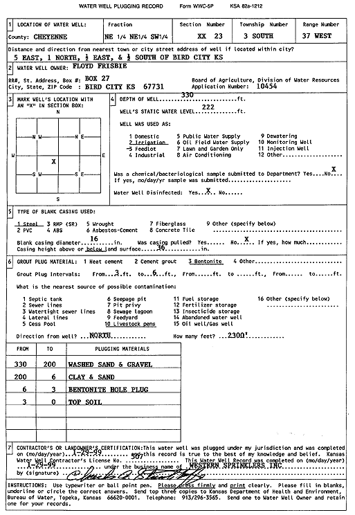
Specific Water Well Detail |
|
|
| Location Info | |||
| Owner: Frisbie, Floyd | Status: Plugged | ||
| Location: T3S, R37W, Sec. 23, NE NE SW | County: Cheyenne | ||
| Directions: from Bird City, 5 mi E, 1 mi N, 0.5 mi E, and 0.5 mi S | |||
| Latitude: 39.7776857 | Longitude: -101.4391189 | Datum NAD 27 | |
| Latitude: 39.777682 | Longitude: -101.4395604 | Datum NAD 83 | |
| Longitude and latitude calculated by Survey from township-range-section-quarter calls. Only good to within the quarter call accuracy. | |||
| View well on interactive map | |||
| General Info | ||
| Well Depth: 330 ft. | Elevation: ft. | |
| Static Water Level: 222 ft. | Est. Yield: gpm. | |
| Comp. Date: 29-Jan-1999 | Well Use: Irrigation | |
| DWR Applic. #: 10454 | Other ID: | |
| Links | |
| View info from Wizard Water Level Data base... | |
| View info from WIMAS Water Right Data base... | |
| Driller Info | ||
| Driller: Western Sprinklers Inc. | License #: 507 | |
| Scanned Form | View scan |
| Casing Info | ||
|
Casing Type:
Diam: in. Casing height above land surface: in | ||
| Grout Info | ||
| Grout used: | From: to ft | |
| Source of Possible Contamination | ||
| Source: | ||
| Direction from well: | Distance: ft | |