|
|
|
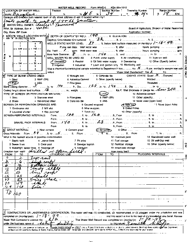
Specific Water Well Detail |
|
|
| Location Info | |||
| Owner: Townsend, Charles | Status: Constructed | ||
| Location: T14S, R19E, Sec. 34, NE NE NE | County: Douglas | ||
| Directions: from Hwy 59 and Hwy 56, 1 mi N and 0.5 mi W | |||
| Latitude: 38.7960459 | Longitude: -95.2799235 | Datum NAD 27 | |
| Latitude: 38.796052 | Longitude: -95.280175 | Datum NAD 83 | |
| Longitude and latitude calculated by Survey from township-range-section-quarter calls. Only good to within the quarter call accuracy. | |||
| View well on interactive map | |||
| General Info | ||
| Well Depth: 140 ft. | Elevation: ft. | |
| Static Water Level: 27 ft. | Est. Yield: gpm. | |
| Comp. Date: 18-Jan-1999 | Well Use: Domestic | |
| DWR Applic. #: | Other ID: | |
| Driller Info | ||
| Driller: Kenneth Schutz Drilling | License #: 212 | |
| Scanned Form | View scan |
|
Chemical Sample Submitted?:
Water Well disinfected?: | ||
| Casing Info | ||
| Casing Type:
Casing Joints: |
Diam: in. to ft | |
| Casing height above land surface: in
Casing Weight: lbs/ft Wall thickness or gauge no.: | ||
| Screen and Perforation Info | ||
| Screen Type: | Screen Openings: | |
| Screen-perforated intervals | From: ft to ft | |
| Gravel pack intervals | From: ft to ft | |
| Grout Info | ||
| Grout used: | From: to ft | |
| Source of Possible Contamination | ||
| Source: | ||
| Direction from well: | Distance: ft | |
| Lithologic Log
(Log data entered by KGS.) | ||
| From: 0 ft. to 2 ft. | top soil | |
| From: 2 ft. to 6 ft. | sand rock | |
| From: 6 ft. to 12 ft. | yellow clay | |
| From: 12 ft. to 32 ft. | sandy shale | |
| From: 32 ft. to 35 ft. | lime rock | |
| From: 35 ft. to 65 ft. | shale | |
| From: 65 ft. to 83 ft. | limey shale | |
| From: 83 ft. to 139 ft. | shale | |
| From: 139 ft. to 140 ft. | limestone | |