|
|
|
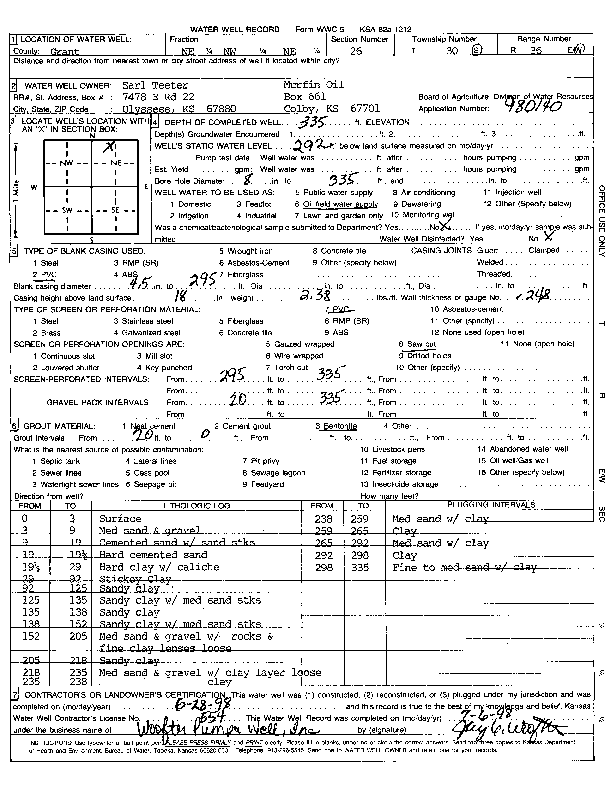
Specific Water Well Detail |
|
|
| Location Info | |||
| Owner: Teeter, Earl/ Murfin Oil | Status: Constructed | ||
| Location: T30S, R36W, Sec. 26, NE NW NE | County: Grant | ||
| Directions: | |||
| Latitude: 37.4159712 | Longitude: -101.2216933 | Datum NAD 27 | |
| Latitude: 37.4159948 | Longitude: -101.222136 | Datum NAD 83 | |
| Longitude and latitude calculated by Survey from township-range-section-quarter calls. Only good to within the quarter call accuracy. | |||
| View well on interactive map | |||
| General Info | ||
| Well Depth: 335 ft. | Elevation: ft. | |
| Static Water Level: 292 ft. | Est. Yield: gpm. | |
| Comp. Date: 28-Jun-1998 | Well Use: Oil Field Water Supply | |
| DWR Applic. #: 980140 | Other ID: | |
| Links | |
| No Wizard information available. | |
| View info from WIMAS Water Right Data base... | |
| Driller Info | ||
| Driller: Woofter Pump & Well, Inc. | License #: 554 | |
| Scanned Form | View scan |
|
Chemical Sample Submitted?:
Water Well disinfected?: | ||
| Casing Info | ||
| Casing Type:
Casing Joints: |
Diam: in. to ft | |
| Casing height above land surface: in
Casing Weight: lbs/ft Wall thickness or gauge no.: | ||
| Screen and Perforation Info | ||
| Screen Type: | Screen Openings: | |
| Screen-perforated intervals | From: ft to ft | |
| Gravel pack intervals | From: ft to ft | |
| Grout Info | ||
| Grout used: | From: to ft | |
| Source of Possible Contamination | ||
| Source: | ||
| Direction from well: | Distance: ft | |
| Lithologic Log
(Log data entered by KGS.) | ||
| From: 0 ft. to 3 ft. | Surface | |
| From: 3 ft. to 9 ft. | Med sand and gravel | |
| From: 9 ft. to 17 ft. | Cemented sand with sand streaks | |
| From: 17 ft. to 19.5 ft. | Hard cemented sand | |
| From: 19.5 ft. to 29 ft. | Hard clay with caliche | |
| From: 29 ft. to 92 ft. | Sticky clay | |
| From: 92 ft. to 125 ft. | Sandy clay | |
| From: 125 ft. to 135 ft. | Sandy clay with medium sand streaks | |
| From: 135 ft. to 138 ft. | Sandy clay | |
| From: 138 ft. to 152 ft. | Sandy clay with medium sand streaks | |
| From: 152 ft. to 205 ft. | Med sand and gravel with rocks and fine clay lenses loose | |
| From: 205 ft. to 218 ft. | Sandy clay | |
| From: 218 ft. to 235 ft. | Med sand and gravel with clay layer loose | |
| From: 235 ft. to 238 ft. | clay | |
| From: 238 ft. to 259 ft. | Med sand with clay | |
| From: 259 ft. to 265 ft. | Clay | |
| From: 265 ft. to 292 ft. | Med sand with clay | |
| From: 292 ft. to 298 ft. | Clay | |
| From: 298 ft. to 335 ft. | Fine to medium sand with clay | |