|
|
|
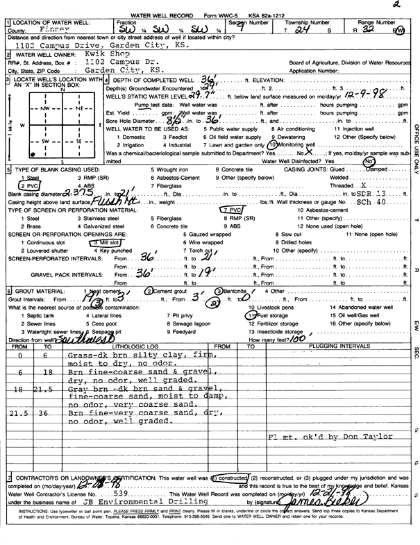
Specific Water Well Detail |
|
|
| Location Info | |||
| Owner: Kwik Shop, Inc. | Status: Constructed | ||
| Location: T24S, R32W, Sec. 9, SW SW SW | County: Finney | ||
| Directions: 1102 Campus Drive, Garden City | |||
| Latitude: 37.9758424 | Longitude: -100.8455297 | Datum NAD 27 | |
| Latitude: 37.9758652 | Longitude: -100.8459682 | Datum NAD 83 | |
| Longitude and latitude calculated by Survey from township-range-section-quarter calls. Only good to within the quarter call accuracy. | |||
| View well on interactive map | |||
| General Info | ||
| Well Depth: 36 ft. | Elevation: ft. | |
| Static Water Level: 29.7 ft. | Est. Yield: gpm. | |
| Comp. Date: 08-Dec-1998 | Well Use: Monitoring well/observation/piezometer | |
| DWR Applic. #: | Other ID: MW 2 | |
| Driller Info | ||
| Driller: JB Environmental Drilling | License #: 539 | |
| Scanned Form | View scan |
|
Chemical Sample Submitted?:
Water Well disinfected?: | ||
| Casing Info | ||
| Casing Type:
Casing Joints: |
Diam: in. to ft | |
| Casing height above land surface: in
Casing Weight: lbs/ft Wall thickness or gauge no.: | ||
| Screen and Perforation Info | ||
| Screen Type: | Screen Openings: | |
| Screen-perforated intervals | From: ft to ft | |
| Gravel pack intervals | From: ft to ft | |
| Grout Info | ||
| Grout used: | From: to ft | |
| Source of Possible Contamination | ||
| Source: | ||
| Direction from well: | Distance: ft | |
| Lithologic Log
(Log data entered by KGS.) | ||
| From: 0 ft. to 6 ft. | grass- dk brn silty clay, firm, moist to dry, no odor | |
| From: 6 ft. to 18 ft. | brn fine-coarse sand and gravel, dry, no odor, well graded | |
| From: 18 ft. to 21.5 ft. | gray brn-dk brn sand and gravel, fine-coarse sand, moist to damp, no odor, very coarse sand | |
| From: 21.5 ft. to 36 ft. | brn fine-coarse sand, dry, no odor, well graded | |