|
|
|
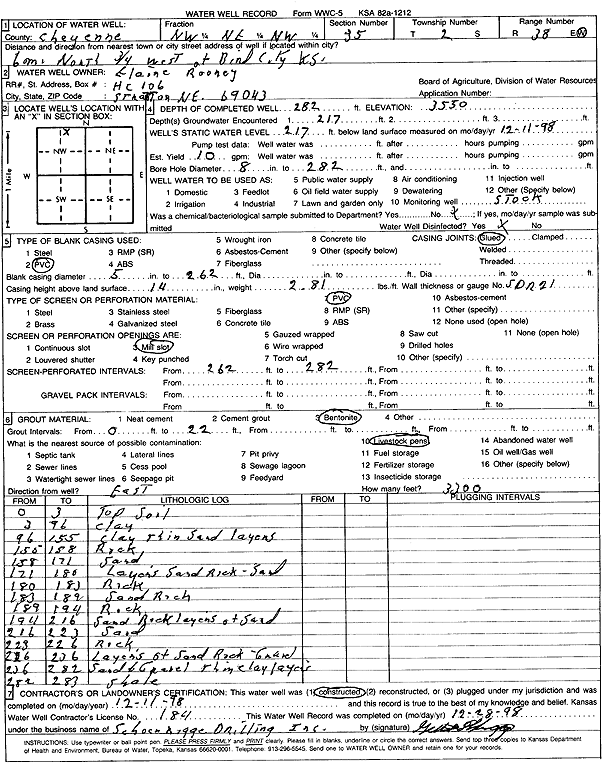
Specific Water Well Detail |
|
|
| Location Info | |||
| Owner: Rooney, Elaine | Status: Constructed | ||
| Location: T2S, R38W, Sec. 35, NW NE NW | County: Cheyenne | ||
| Directions: from Bird City, 6 mi N and 0.75 mi W | |||
| Latitude: 39.8428713 | Longitude: -101.5534889 | Datum NAD 27 | |
| Latitude: 39.8428664 | Longitude: -101.5539335 | Datum NAD 83 | |
| Longitude and latitude calculated by Survey from township-range-section-quarter calls. Only good to within the quarter call accuracy. | |||
| View well on interactive map | |||
| General Info | ||
| Well Depth: 282 ft. | Elevation: 3550 ft. | |
| Static Water Level: 217 ft. | Est. Yield: 10 gpm. | |
| Comp. Date: 11-Dec-1998 | Well Use: Domestic, Livestock | |
| DWR Applic. #: | Other ID: | |
| Driller Info | ||
| Driller: Schoenrogge Drilling, Inc. | License #: 184 | |
| Scanned Form | View scan |
|
Chemical Sample Submitted?:
Water Well disinfected?: | ||
| Casing Info | ||
| Casing Type:
Casing Joints: |
Diam: in. to ft | |
| Casing height above land surface: in
Casing Weight: lbs/ft Wall thickness or gauge no.: | ||
| Screen and Perforation Info | ||
| Screen Type: | Screen Openings: | |
| Screen-perforated intervals | From: ft to ft | |
| Gravel pack intervals | From: ft to ft | |
| Grout Info | ||
| Grout used: | From: to ft | |
| Source of Possible Contamination | ||
| Source: | ||
| Direction from well: | Distance: ft | |
| Lithologic Log
(Log data entered by KGS.) | ||
| From: 0 ft. to 3 ft. | Topsoil | |
| From: 3 ft. to 96 ft. | Clay | |
| From: 96 ft. to 155 ft. | Clay thin sand layers | |
| From: 155 ft. to 158 ft. | Rock | |
| From: 158 ft. to 171 ft. | Sand | |
| From: 171 ft. to 180 ft. | Layers sand rock, sand | |
| From: 180 ft. to 183 ft. | Rock | |
| From: 183 ft. to 189 ft. | Sand rock | |
| From: 189 ft. to 194 ft. | Rock | |
| From: 194 ft. to 216 ft. | Sand rock layers of sand | |
| From: 216 ft. to 223 ft. | sand | |
| From: 223 ft. to 226 ft. | Rock | |
| From: 226 ft. to 236 ft. | Layers of sand rock, gravel | |
| From: 236 ft. to 282 ft. | Sand and gravel thin clay layers | |
| From: 282 ft. to 283 ft. | Shale | |